 |
 |
 |
| For a full overview click here |
|---|
The Marlborough Sundial Trail in Wiltshire, England |
| |
|
|
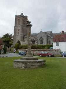
| The Marlborough Sundial Trail provides a good framework
for an expedition to see the varied and interesting countryside around
Marlborough. You will probably find it helpful to look at the map
before you start. On this map, the arrow points at Preshute in the middle
of the trail. Little Bedwyn where the trail starts is on the extreme right
of the map, just south of the A4, and Broad Hinton, where the trail finsihes,
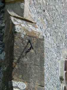
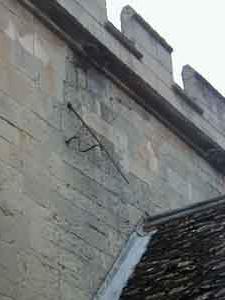
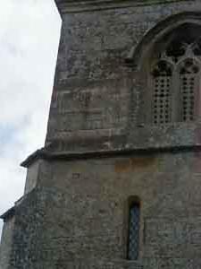
is near the A4361 and north-west of Marlborough. The tour starts at St. Michael's Church at Little Bedwyn. The sundial is on the south-east buttress, and is rather weathered. Come out of the church, past the row of cottages and turn right towards Chisbury. In Chisbury, turn right and keep straight on signed to Ramsbury Go straight across the main A4 with great care and a couple of miles further on, you turn left (signed Ramsbury and Aldbourne. Cross the River Kennet to Ramsbury, and continue through the village. When you get to the crossroads in the centre of Ramsbury, turn left straight through the village and the Church of the Holy Cross is on your right hand side a little way away from the road. The sundial is almost south-facing over the church door
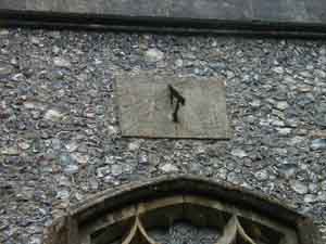
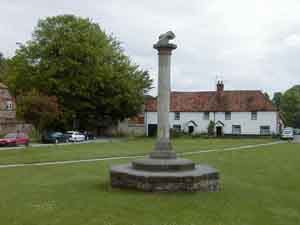
If you are on a mountain bike, push it through the churchyard and out on the gravel drive at the back, turn right and then left at the school sign up Love Lane. This is an ancient track over Southward Down to Aldbourne. Otherwise, retrace your path for a hundred yards, and then take the left fork towards the village of Whittonditch. At the crossroads in Whittonditch, turn left on the B4192 to Aldbourne. On the village green in Aldbourne is a column which appears to have a cross dial mounted on top (and thus in a position where it is not possible to see the hour markings). It appears to be pointing in the correct direction to give accurate readings, but you would need a ladder to read it! From here, retrace your route for a hundred yards or so, and turn right on to Southwood Lane. Near the top of the hill, a track goes straight on, and you follow the metalled road signed "Byway Ewin's Hill" On the top of the Downs,where there's a nearly dead oak tree with a No Tipping notice you go right. contniue on to the T-juncition where you turn left down a marvellous steep hill,. lined with wide ribbons of cow parsley stretching right down to the valley when we did it in May. At the T-junction in the valley, turn right and go 3 miles along the road following the River Kennett, through Axford into Mildenhall. The church of St. John is 150 yards off to the left towards the riiver. It has a vertical sundial on the south-west buttress.
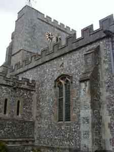
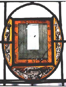
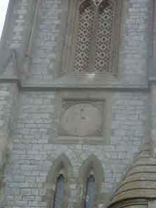
Return to the main road, turn left and follow the road into the centre of Marlbrough to the parish church of St. Mary the Virgin at the eastern end of the High Street. There is a vertical dial with a rather elegant scrolled gnomon support on the South wall over the porch. This is likely to have had a painted dial plate on the wall behind it at one time, but there are almost no traces of it now. A hundred yards or so down the High Street on the North side is the Merchant's House. This is one of the oldest houses in Marlborough, and is open to the public. On the first floor is a very unusual stained glass dial. This has two mottoes "Dum Spectas Fugio" and "Sic Vita". It was probably made in the late 1600s. Like most stained glass dials, the gnomon which casts the shadow is missing. It is ironic that stained glass dials keep their hour lines as fresh as new but lose their gnomons very easily; stone dials keep their gnomons long after the dial markings have been totally eroded. Continue on down the High Street past the (now redundant) church at the far end, and follow the main road to the right and then the left as it winds round Marlborough College. If you are on a bicycle there is a footpath a few feet after the driveway going down to the Memorial Hall of the college; the footpath winds through water meadows and a bridge over the Kennet to end up at the church of St. George's, Preshute. If you are travelling by car, continue further down the A4, and take the first turning on the left.
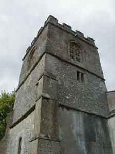
The next stop is the church of St. Michael and All Angels in West Overton. The best route for cyclists is the back way through Manton, Clatford, and Lockeridge. Approaching Lockeridge, there is a cross roads with a dirt road on the left, and you turn right. At the bottom of the hill, turn right and immediately left for West Overton. Approaching West Overton, turn right down hill to the church. Motorists may prefer to go back to the A4, turn left, and take the fifth turning on the left signed to West Overton. This sundial is interesting because it has a cicular dialplate to match the clock on the other side of the tower. The gnomon is missing. There are two mottoes "Watch and Pray" and "Time steals away". This dial is in course of restoration as a result of the generosity of a local landowner - and perhaps as an indirect result of the research for this sundial trail.
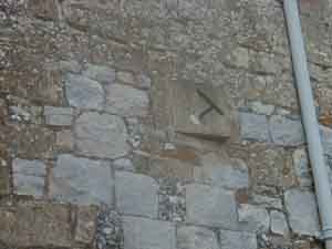
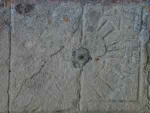
From West Overton, continue along the back road to East Kennett. This area is full of very ancient remains, including the West Kennett Long Barrow on the hill behind you. This well repays a detour.Also, Silbury Hill is less than a mile along the A4 towards Bath - this is a huge artificial mound whose original purpose is unknown. From the junction, go west along the A4 for a few hundred yards, and then turn right on the B4003 towards Avebury. Notice the stones of the Avenue on your left. The village of Avebury is built mainly inside the ancient stone circle, which makes a very pleasant walk. The church of St. James has an interesting sundial which is canted out from the wall so that it faces due South. South facing dials are much easier to delineate, though in this case all the numerals except for the XII of noon have weathered away. Continue north on the B4003 through Winterbourne Monkton to Berwick Bassett. On the south wall of the redundant church of St. Nicholas is a scratch dial or mass dial. These dials all date from medieval times. Then continue further on the B4003 and take the second turning left to Broad Hinton, where our sundial trail ends. St. Peter's Church has an octagonal dial, also angled out from the wall to face south, and with the motto "Our days on the earth are but a shadow" - a suitably sombre note on which to leave the Marlborough sundial trail! |
|
|
|---|
| This complete website © Internetworks, 1997-2007. The site was designed and is maintained by Internetworks Ltd of Epsom, England |
| last revision |
| Comments/ suggestions/ problems, please get in touch with the Webmaster |