
|
| For a full overview click here |
|---|
The Guernsey Sundial Trailby David and Dorothy Le Conte |

|
| You can click on any image to get a full screen version 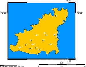
The Guernsey Sundial Trail is a tour of 17 historic and significant sundials in the Island of Guernsey. It includes several of the Island's churches, as well as public buildings, private houses and a tourist attraction. The dial ages and types range from ancient and vertical, through recent and horizontal, to ultra-modern. The oldest are the church dials. Granite is the natural local building stone, but its hardness makes it difficult to carve accurate hour lines and symbols. The dials are mostly of limestone, probably imported from France. Indeed, it could well be that they were carved in France. No two are the same. Most, especially the church dials, are vertical direct south-facing dials, and are undoubtedly at least two hundred years old. While it is possible to carry out the tour by public transport, a car or bicycle is almost essential. In the sequence listed here the total journey is 28 miles (45 km). Allow a full day for the tour (longer if by bus or bicycle). Alternatively, of course, individual dials may be more conveniently visited when you happen to be in the area. Guernsey's roads are not the easiest to navigate, and you will need a good map. You may find a pair of binoculars of assistance in examining some of the details of the dials, which are invariably mounted high on walls. A picnic may be taken, or a visit made to one of the excellent hostelries en route. Locations are specified by reference to the local Perry's Guide (PG) map, longitude and latitude, and the Guernsey Grid, as well as by road and parish. For vertical dials the declination of the wall on which the dial is mounted is also given. This is the angle which the wall makes with due South. All such dials, however, on this trail are Direct South dials, ie they are designed to point directly south, and are necessarily angled out from the wall. The declinations have been determined from the Guernsey GIS digital map. The authors acknowledge with thanks the assistance of: Keith Blondel, David and Audrey Dickins, Geoff Falla, Simon Goodwin, Richard Hocart, Hugh and Gillian Lenfesty, John McCormack, David Roblliard, Alan Smith, Gregory Stevens Cox and Douglas Timms. Information about the churches has been largely sourced from Channel Island Churches by John McCormack (Phillimore, 1986), and some dates are taken from his book The Guernsey House and from Buildings in the Town and Parish of St Peter Port by C E B Brett. We would be pleased to hear of any additional dials which readers may find and which may be worthy of inclusion on the trail. 1. Slaughterhouse Castle Emplacement, St Peter Port (PG T L9, longitude W 02° 32' 04", latitude N 49° 27' 11", grid ref 38432 44735). Vertical dial. Wall declines 6.4° west of south. 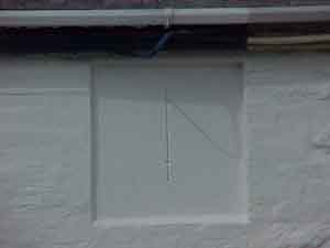 The tour starts at the south end of the town of St Peter Port. At the
landward end of the emplacement reaching out to Castle Cornet is the old
slaughterhouse, a long, low granite building. Go onto the upper walk just
south of the building, and look over the wall surrounding it, at the point
just left of the small door. The dial, its gnomon missing, is barely visible
as it is painted white as part of the wall on which it is mounted, the
hour lines obliterated by the paint. Above it, not legible from the upper
walk, is the inscription: "Pierre de Havilland, Ecuyer, Supervi de la
Chaussée. Ex hoc Momento pendet Æternitas." (From this moment hangs eternity.)
Pierre de Havilland (1747 - 1821), Esquire, was Supervisor of the Harbours in 1788, and the dial can be assumed to date from then. It was presumably moved from elsewhere on the Harbour, as the slaughterhouse was built in 1887. It is angled slightly (but perhaps not enough) to the east to take account of the declination of the wall. It is to be hoped that the paint will be removed and dial restored. 2. Guernsey Liberation Monument Weighbridge, St Peter Port (PG T L5 and page 19, longitude W 02° 31' 59", latitude N 49° 27' 33", grid ref 38490 45374). From a rather disappointing appearance of an historic dial, we come to a spectacular modern one. Go northwards along the waterfront of St Peter Port for 0.5 miles (0.8 km), turn right at the roundabout near the clock tower, and park in the North Beach car park. From there walk south-west towards the Weighbridge clock tower and the Liberation Monument whose pointed obelisk stands near the clock tower. 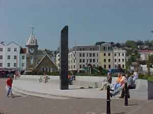 It is a modern construction of an unusual, and perhaps unique design.
It consists of a dark granite obelisk, over 5 metres high, and a long
curve of light granite seating, frequently occupied by many people waiting
for Herm ferries or enjoying the sun and the view. Erected in 1995, it
commemorates the 50th Anniversary of the Liberation of the Island from
Occupation by German armed forces on the 9th May 1945. It stands on the
spot where the liberating British forces were greeted by the Guernsey
people on that day.
 Although not a sundial in the normal sense of the term, it is accurately designed so that the tip of the shadow of the obelisk precisely follows the curve of seating on the 9th May each year, and points, at the appropriate times, to inscriptions of events which happened on Liberation Day 1945. Designed by local artist Eric Snell, with detailed astronomical calculations carried out by David Le Conte, it was unveiled by HRH The Prince of Wales on the 9th May 1995. The design tolerances were 0.01° and 1 mm, and its accuracy is estimated at 5 seconds of time. A plaque on the wall of the clock tower describes the Monument in more detail, and an explanatory leaflet is available at the Tourist Information Centre in the large grey granite building south of the Monument. Further information can be found in articles in the Report and Transactions 1997 of La Société Guernesiaise, Vol XXIV, Part II, and the Bulletin of the British Sundial Society, No. 97.3, July 1997. 3. St Sampson's Church Church Road, St Sampson's (PG 11 F3, longitude W 02° 30' 55", latitude N 49° 28' 56", grid ref 39759 47927). Vertical dial. Wall declines 2.7° east of south. Now drive north along the waterfront, for a distance of 2.0 miles (3.2 km). After you pass the oil storage tanks the road bears sharply left as you enter the area of St Sampson's Harbour. After the bend, turn left almost immediately (at a small weighbridge), into Church Road. The parish church of St Sampson is on the left of the road, and there is a small car park just past the Church. 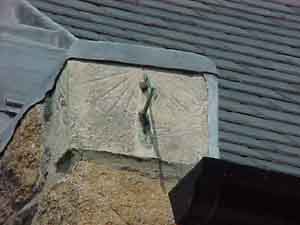 The dial is on the south-west corner of the 12th century Church. It is
made of limestone, and is angled slightly from the line of the wall to
compensate for the wall's declination. As with many church sundials mounted
on the gable corners, it is severely encroached upon by a gutter and lead
which covers the upper hour lines and the right (east) side. Dial markings
are visible on the south and west sides, and it is possible that the east
side was also a dial. The south face has a metal gnomon, undoubtedly a
replacement for the original. No numbers are visible, although there is
an attractive double semicircle on the south face. The holes for the mounting
of a gnomon on the west face can be seen. There may possibly have been
an inscription beneath the south face of the dial at one time.
 4. Vale Church St Michel du Valle, La Route de L'Ancresse, Vale (PG 6 B5, longitude W 02° 32' 19", latitude N 49° 29' 39", grid ref 38091 49205). Vertical dial. Wall declines 12.3° east of south. The Vale Parish is the northernmost on the Island, and the land on which the Parish Church stands used to be separated from the main part of Guernsey by a sea channel called the Braye du Valle, which could be crossed at low tide or, at the eastern end, via a bridge where the small shopping town of St Sampson's now stands. Land reclamation in the 19th century joined the two parts of the Island. From St Sampson's Church continue along the one-way Church Road, turning right at the end, and passing through the shopping area at St Sampson's Harbour, which is still called The Bridge. Go straight on at the small roundabout at the north end of the shopping area, into Vale Avenue, and at the cross-roads turn left into Braye Road. Continue until you reach traffic lights, and then turn right onto the Route Militaire. After a further 0.5 mile (0.8 km) you will see the church on the left side of the road, with a car park in front. Walk up the long drive to the Church door, and proceed around the west side. The sundial is about 4 metres up on the wall at the south-west corner of the church, at the base of the tower.  The Church of St Michel du Valle dates from the 12th century, when it
belonged to Mont St Michel in Normandy, but there have, of course, been
considerable additions and alterations in the succeeding centuries. It
is in a beautiful setting, rising high on a mound ('hougue') at the end
of the otherwise flat Braye. It can, therefore, be seen from a long distance.
The dial is a vertical one, made of limestone, and is angled sharply west from the wall because of the church's 12 degree east declination. A wall lamp hangs incongruously alongside it. Below stands a christianised menhir. The dial is fairly crude, with no numerical identification of the hour lines, but the lines themselves, running from 6 am to 6 pm, are still clearly visible. The dial is an interesting shape, being an inverted semicircle with a 'plinth' extension at the base. The gnomon, as with most such ancient dials, is missing, but the two holes for its support are evident, indicating that it would indeed have properly been at an angle to the face of the dial, corresponding to the co-latitude (90° minus the latitude) rather than horizontal. Its age is uncertain, but it must be several hundred years old, and could well be contemporary with that part of the building (end of the 12th century). Certainly it has the appearance of being much older than the St Sampson's Church dial. If you have time you may note a 20th century horizontal sundial on a gravestone in the cemetery to the north of the church. It is located near the centre of the northernmost section of the cemetery (Cimetière Paroissial 1921), at the grave of Charles Gilroy Ross, who died on March 2nd 1936. The bronze dial is presumably from that date. It stands on a rather nice plinth of pink Guernsey granite. The dial is almost screened by a trimmed box hedge which curiously grows on the grave. The design of this dial has, in modern times, been copied by a local stonemason to make dials out of slate. 5. Castel Church Ste Marie du Castel, La Rue du Presbytère, Castel (PG 15 H4, longitude W 02° 34' 20", latitude N 49° 27' 35", grid ref 35661 45438). Vertical dial. Wall declines 0.1° east of south. 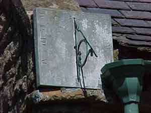 Now return to the traffic lights at Route Militaire and Braye Road, and
turn right. Follow the main road for 1.9 miles (3.1 km), through three
more sets of traffic lights, and turn left at the second filter-in-turn,
into La Rue du Friquet. At the next set of traffic lights carry straight
on, up Rectory Hill (La Rue du Presbytère). As you approach the top of
the hill you will see the Church high up on the left of the road. The
Church car park is just before you reach the Church.
 The square, vertical dial is on the south-west corner of the Church of Ste Marie du Castel, slightly marred by obtrusive guttering. Of all the Guernsey churches bearing dials, the Castel Church is the most accurately aligned east-west, so the south-facing dial is parallel with the line of the church. Although it is weathered, the markings are still visible: Roman numerals, with hour lines and half-hour and quarter-hour marks. It also has three curves which must have been intended as solstice and equinox lines. Although the curves are not correct, their intention as seasonal lines is borne out by the design of the gnomon's style, which is intact and bears a nodus in the form of a notch and spike. The shadow of the nodus would indicate the season. The dial is a sophisticated 'scientific' one, is in good condition, and must be comparatively recent, probably not more than a couple of hundred years old. The church itself has several interesting features. Standing on the site of what may have been an ancient castle, which gives the parish its name, the church dates from the 12th century. The part where the sundial is dates from the late 14th century, although, as noted above, the dial must be considerably later. Near the church entrance is a medieval granite trough with the carved heads of a lion and a leopard. On the north side of the entrance stands a granite Mother Goddess, and below it a fief seat. An accompanying plaque provides information on these stones. Inside the church are 13th century frescoes, and a hagioscope or squint pierces one of the pillars. 6. Les Fauconnaires Farm La Route des Fauconnaires, St Andrew's (PG 16 B5, longitude W 02° 34' 00", latitude N 49° 27' 20", grid ref 36097 45044). Vertical dial. Wall declines 21.5° east of south.  From the Castel Church car park carry on up Rectory Hill, and go straight
at the traffic lights. After 0.8 miles (1.3 km), on Bailiff's Cross Road,
turn left at a bus stop into La Route des Fauconnaires. This narrow road
winds downwards, and the first farmhouse on the left is Les Fauconnaires
Farm.
 The vertical sundial is on the leftmost chimney, and can just be seen from the road, through a small vehicular gateway just before the farm. It is made of limestone, and is clearly ancient (probably several hundred years) and very weathered. Its gnomon is missing, and no lettering is visible. Closer inspection reveals faint traces of hour lines. 7. St Andrew's Church St André de la Pommeraye, St Andrew's Road, St Andrew's, (PG 23 G3, longitude W 02° 34' 32", latitude N 49° 26' 45", grid ref 35369 43891). Vertical dial. Wall declines 0.8° east of south. 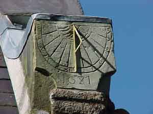 Go back up to Bailiff's Cross Road, turn left and then right at the traffic
lights, onto St Andrew's Road. After 0.7 miles (1.1 km) you will reach
St Andrew's Church. There is a car park just before the church, on the
right side of the road.
 The dial is at the south-east corner of the church, facing the road. Like the St Sampson's dial, it has a covering of lead, although this time the lead does not encroach on the dial face. The dial is in very good condition, in fact undoubtedly too good. It has the distinct appearance of having been recut not very long ago, and a new gnomon, probably not of the original design, added. The date 1681 is clearly visible, and there are Roman hour marks, with a wavy decoration around the base of the gnomon, which itself is too new for the date of the dial. 8. Le Moulin de Haut Rue Pantain, Talbot Valley, Castel (PG 14 D5, longitude W 02° 35' 45", latitude N 49° 27' 20", grid ref 33985 44985). Vertical dial. Wall declines 26.0° east of south.  From the St Andrew's Church car park turn left, and then immediately bear
left into L'Ecluse. At the end of the road turn left again, into Talbot
Valley. This is a rather lovely drive through the biggest valley in Guernsey,
and you will need to go almost to the very end of it, a distance of 1.2
miles (1.9 km). After the road curves fairly sharply left it bears right,
and at that point there is a small grass triangle with a tree in the middle,
on the left side of the road, marking the entrance to a narrow dead-end
lane. Park there and walk the few yards along the lane to Le Moulin de
Haut, the large house on the right.
 The dial is at the base of the left chimney, wedged out to face direct south. It is a rather fine dial, dated 1769. It has a complete gnomon and hour lines from 6 am to 6 pm, and is inscribed with the letters "IDMR". The house itself dates from the late 16th or early 17th century, but it was refashioned in the 18th century. The stone over the front door has a curious carving said to be associated with the Lefebvre family. There is a pleasant walk straight ahead along the lane called La Rue Paintain (return the same way), with bluebell-carpeted woods in April. 9. St Saviour's Church, Le Neuf Chemin, St Saviour's (PG 21 H3, longitude W 02° 36' 47", latitude N 49° 26' 47", grid ref 32644 43923). Vertical dial. Wall declines at 19.5° east of south. 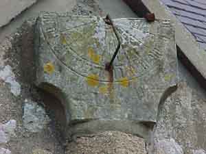 From the grass triangle, continue the same way you were driving, and turn
left at the end of the road, where there is the large King's Mills water
pumping station, dated 1848, on your right. This is the farmhouse-studded
Les Grandes Moulins (King's Mills) Road. After a short distance, just
past the Hotel Fleur du Jardin, at a small odd-shaped house, bear left
up La Route de la Hurette. Continue right up this narrow, winding road
for 1.0 miles (1.6 km), and at the end turn right. The church is immediately
in front of you, and you can park along the roadside.
 The dial is above the south door, so you need to go around the other side of the church. It is a rather fine direct south-facing dial, angled well out from the wall, to offset the wall's declination. This dial is well known, and is mentioned in Channel Island Churches, which says that the stone on which it stands was a 15th century statue bracket, that the dial is a "repositioned but ancient mass-dial, its gnomon missing", and that it is the only mass-dial left in the Channel Islands. It is, actually, not a mass dial (which is usually a crudely scratched dial with, probably, a horizontal gnomon, and of which no examples have been found in Guernsey), but, in common with other Guernsey church dials, is of the form known as 'scientific', with a gnomon angled to a direction parallel with the Earth's axis, and designed to show actual hours, rather than mass times. They typically date from the 16th century, as compared with the medieval mass-dials, which, in Britain, were themselves preceded by the more sophisticated 'Anglo-Saxon' dials dating from AD 650 to 1050. It is possible that this dial does date from that period, or rather later, and it has some similarities in appearance and lettering, to the Lihou island priory sundial discovered in 1999, which itself cannot be later than 16th century, and may well be earlier. It also bears similarities with a dial dated 1578 at Chartres Cathedral. It is possible, however, that the St Saviour's Church dial has been re-cut at some time, as the lettering appears to be in too good condition for its age. Indeed, there is evidence that some refurbishment of the dial must have taken place, as the gnomon is almost certainly not original. It is a rather crudely installed piece of metal, whose base (at the top of the gnomon) does not coincide with the dial centre (where the hour-lines meet). Other items of interest include a 20th century sundial on the Wyse family grave in the cemetery, and a christianised menhir at the small gateway east of the church. 10. Bruce Russell Gold and Silversmiths La Route des Frances, St Saviour's (PG 28 B1, longitude W 02° 36' 28", latitude N 49° 26' 17", grid ref 33020 43008). Armillary sphere. 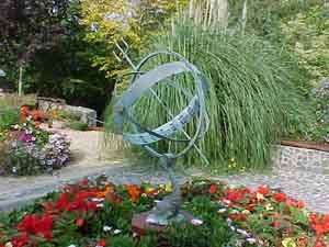 From St Saviour's Church turn around and go right, along Les Buttes, then
first right onto La Route des Bordages. There is a brown tourist sign
pointing marked "Gold and Silversmith", and stone inscribed "Le Gron".
Continue on this road until you see a similar sign pointing right. After
a short distance you will reach this tourist attraction, where there is
a car park.
 The armillary sphere is the centrepiece of an ancient cider press, near the entrance to the building. It is modern, large and embellished with maritime motifs. You may wish to pay a visit to the workshop and showroom, and have a snack at the café. Indeed, this may be a suitable place to stop for lunch during your sundial trail. If you wish to stretch your legs there is a pleasant nature walk. 11. Salle Paroissiale, St Pierre du Bois La Rue des Brehauts, St Pierre du Bois (PG 27 G1, longitude W 02° 37' 40", latitude N 49° 26' 15", grid ref 31752 42894). Polar (book) dial. Wall declines 16.3° west of south. 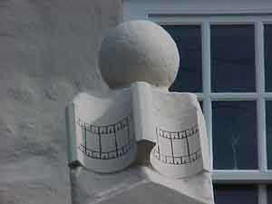 Now continue in the same direction, following the road around until it
joins a larger road (La Route de Plaisance). Keep straight on along this
road, for a short distance. You will pass a grocery store on your right,
and immediately afterwards bear left, at a filter-in-turn signposted "Parish
Church", off the main road, onto La Rue des Brehauts. You will see the
Church of St Pierre du Bois directly in front of you, set down below the
road level. Park there, and walk the few yards back along the road.
 The dial, shaped like a book, is above the porch of the Salle Paroissiale (Parish Hall). It is surmounted by a stone ball. It is a form of 'polar dial', of the type known as a 'book' or 'open book' dial. Its date is uncertain. However, the building dates from the late 18th century, the porch being added in the early 19th century, and it served as the parish school until the new school was built in 1900, when it became an infants' school until around the First World War. It therefore seems likely that the dial dates from the school period, probably the 19th century, and its book form would be appropriate to its school context. The dial is repainted periodically, and the hour lines are undoubtedly no longer in the correct positions. The dial is angled slightly off alignment with the building, but does not point directly south, so the hour lines should be different on each side of the central gnomon. The thickness of the gnomon also means that the style casting the morning shadow is different from that for the afternoon shadow. Until a few years ago it had the words Morning and Afternoon painted quite incorrectly on the same side, but at the time of writing this account there are, fortunately, no words. Neither, however, are there any numbers denoting the hours. It is to be hoped that efforts will be made by the parish officials to ensure that the next time it is painted, the hour lines appear in the correct positions, and are numbered. 12. Torteval Parish Cemetery La Route de Pleinmont, Torteval (PG 26 C3, longitude W 02° 38' 47", latitude N 49° 25' 55", grid ref 30353 42174). Horizontal dial. 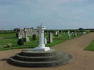 From St Peter's we head to the parish of Torteval, the south-westernmost
parish in the Island. The easiest way to do this is to go back to the
filter-in-turn junction, and turn sharp left. Continue on this road (which
is mostly La Route des Paysans), until you reach the coast. On the way
you will pass close to the Observatory of La Société Guernesiaise (marked
by a large block German bunker on the right side of the road), where there
is sometimes displayed a vertical south-direct dial recently made by members
of the Astronomy Section of La Société. The dial is made of wood, so it
is only displayed when there is a daytime function at the Observatory.
Just after the Observatory, also on the right side of the road, is La
Houguette Primary School, where, in the playground, has been painted an
analemmatic dial. Children stand in the middle of it and act as the gnomon,
their shadow marking the time. There is, however, no public access.
 At the coast road, a distance of 2.0 miles (3.2 km) from St Pierre du Bois, turn left and go a further distance of 2.0 miles (3.2 km) to the Imperial Hotel. The beach along this route could be an excellent place for a picnic. At this point you can stop and look back towards Lihou island in the distance. With binoculars you may be able to spot the ruins of the Priory, where, in 1999, several pieces of an ancient vertical dial, with similarities to the St Saviour's Church dial, were found during an archæological excavation. The dial is in the possession of the Guernsey Museum, and may well be displayed at some time. The island itself is accessible by foot at low spring tides from the headland opposite. Having reached the Imperial Hotel, turn left. The road winds upwards, and there is a sharp left curve. You will eventually see the Torteval Church appearing in front of you, but before you get there look out for the cemetery on your right. The dial is mounted prominently on a pedestal in the centre of the cemetery. It is the only horizontal dial on this sundial trail, and is included because it the best public horizontal dial in the Island. It is dated 1934, and has hour lines marked from 4.00 am to 8.00 pm. It is engraved with the initials 'TPC' (possibly referring to Torteval Parish Cemetery), and the motto "L'Eternal nous est un soleil et un bouclier" ("For the Lord God is a sun and shield", Psalm 84, line 11). The pedestal on which it stands is the former font from the Torteval Church, the church having been renovated in 1932 and the font replaced by one removed from the former church of St Barnabas (1874) in St Peter Port. 13. Les Marchez La Rue des Reines, St Pierre du Bois (PG 27 H3, longitude W 02° 36' 53", latitude N 49° 25' 48", grid ref 32579 42077). Vertical dial. Wall declines 4.7° east of south. 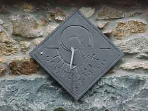 Now continue along the road for a distance of 1.4 miles (2.3 km). Where
the main road turns sharply right for the second time, at La Croute, you
must turn sharp left, into a narrow road called Les Menages. At the first
crossroads (La Croix au Marchez) turn first right, into La Rue des Reines,
and stop at the first house on your left. This is Les Marchez.
 Over the front door of the old farmhouse is a modern vertical dial of an unusual design. It was made by Brookbrae Sundials in the 1980s. The gnomon is shaped like a cat, its tail acting as the style, casting the shadow. The owners had a mouse added to the design to give it additional interest. Even more unusually, the hour lines are marked an hour ahead of Greenwich Time, so that the dial is intended for use in the summertime only. The dial has been carefully and slightly wedged out one side to ensure that it faces due south. Having been made for a UK location, however, the angle which the cat's tail makes with the plane of the dial will be a couple of degrees too small for its new Guernsey latitude. 14. Forest Primary School La Rue des Landes, Forest (PG 28 C3, longitude W 02° 35' 55", latitude N 49° 25' 50", grid ref 33675 42248). Vertical dial. Wall declines 3.6° east of south. 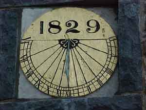 Now go to the end of the road, and turn left. At the junction with the
main road (La Route de Farras) turn right, towards the airport. Shortly
before you reach the airport, you will come to the Forest School on your
left. It is marked by a pedestrian crossing light. If the school is not
in term you may be able to stop in its car park, the entrance being shortly
before you reach the light.
 The dial is brilliant, large and gold-coloured, mounted on the front wall of the school. It is prominently dated 1829, probably marking the date of major refurbishments to the school buildings following its adoption by the Parish in 1828. The school was demolished and rebuilt in 1999, and the dial replaced in its present position at that time. It is angled towards the south. 15. Saxon's Holt Le Bordage, Petit Bot Valley, Forest (PG 28 E3, longitude W 02° 35' 20", latitude N 49° 25' 42", grid ref 34624 42011). Vertical dial. Wall declines 14.6° west of south. 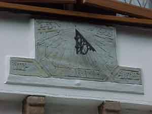 Continue past the airport, and follow the main road as it bears sharply
left. Immediately turn right, towards Petit Bôt Bay. The road goes down
through the valley, past the Manor Hotel. Stop just past the hotel, at
the first house visible on the left of the road, named Saxon's Holt. Beneath
an upper window is an interesting vertical dial. Dated 1969, it was carved
out of Welsh slate by the then owner of the house, Sylvester White. It
carries the motto "Time is fleeting".
 16. St Martin's Church St Martin de la Bellouse, La Beilleuse, St Martin's (PG 24 D5, longitude W 02° 33' 15", latitude N 49° 26' 18", grid ref 37002 43134). Vertical dial. Wall declines 15.6° east of south. 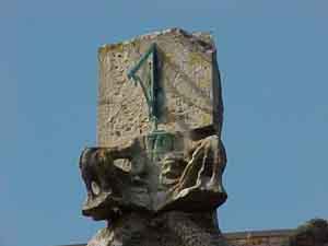 Go back up to the main road, and turn right. Continue for 2 miles (3 km)
until you reach St Martin's, where there is a filter-in-turn junction.
Turn left, and immediately right, down a narrow road towards the church.
At the entrance to the churchyard there is a neolithic standing stone with a distinctively female shape, called La Gran-mère du Cimetière. The sundial, complete with gnomon, is perched above the church door. It is heavily weathered, but the date 1751 on the supporting finial is clear. The porch itself dates from the early 16th century. 17. St Andrew's Church of Scotland, The Grange, St Peter Port (PG T G7, longitude W 02° 32' 30", latitude N 49° 27' 25", grid ref 37820 45124). Vertical dial. Wall declines 3.0° east of south. The final sundial on this trail takes you back to Town. From St Martin's Church go back up to the main road (you can turn sharp right outside the church gate), and turn left. At the traffic light turn left again, towards St Peter Port. Shortly you pass Saumarez Manor where there is an ordinary horizontal dial, and sometimes interesting modern dials displayed as part of the Manor's sculpture trail. However, continue until you reach the end of the road, where it bears sharp right down towards the harbour of St Peter Port. At this point don't follow the road around to the right, but turn sharp left into Colborne Road. At the bottom of this road turn right and then immediately left, at the mini-roundabout, into Prince Albert's Road. At the top, where there is a filter-in-turn, continue straight on, into The Queen's Road. When you reach the bottom of this road you must turn right, into The Grange. (If you turn left you will pass the Ladies' College, where, behind the wall of the Junior School, Melrose, is a modern south declining vertical dial given to the school by retiring Head Teacher Marian Vaudin in 1994. This dial is not accessible by the public.) Go down The Grange and just after the traffic light at the Doyle Road crossroads, on the left side of the road, is the St Andrew's Church of Scotland (not to be confused with the Anglican St Andrew's Parish Church). There is a small parking place in front of the church. If you are walking, do beware of the traffic as there is no pavement on that side of this busy road. 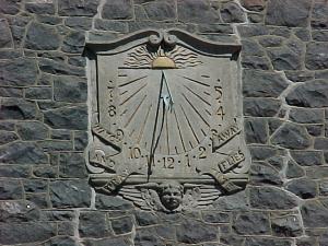
The Church has a rather fine plaster vertical dial high on the front wall. At the top of the dial is a rising (or setting) sun symbol, and at the bottom is the face of a winged cherub. The dial bears a scroll with the motto "Watch and pray. Time flies away." Its date is uncertain; however, the church was opened (as a Presbyterian church) on 16 September 1897, and it is possible that the sundial dates from then. The dial was repaired and repainted in 1988. Although it is designed as a south direct dial, it does not appear to have been angled from the church wall the 3 degrees necessary to make it face due south. This concludes the sundial trail, and you can return into Town and your starting point by continuing down The Grange. We have necessarily omitted a number of interesting, but privately owned dials which cannot be viewed by the public. If anyone knows of dials which we have missed and which are on public view we would be pleased to consider them for inclusion in the trail. We are also interested in any other dials, not necessarily accessible by the public, which could be included in the Register of the British Sundial Society. The late David Le Conte, who wrote this article, had a distinguished career as an astro-physicist, and after his sretirement, as a public official of the States of Guernsey. He published some articles which you may find interesting - please visit his article on the Guernsey Liberation monument at astronomy.org.gg |
| at |
|
|
|---|
| This complete website © Internetworks, 1997-2007. The site was designed and is maintained by Internetworks Ltd of Epsom, England |
| last revision |
| Comments/ suggestions/ problems, please get in touch with the Webmaster |