 For
a full overview click here
For
a full overview click here For
a full overview click here Seattle sundial trail |
|---|
|
This Trail includes eight of Seattle's best dials, with four additional, optional dials for those who have more time. For most folks the Trail will require transport by car, although fit cyclists can certainly do it; the routes described are for a car. Total length of the Trail is 17 miles (27 km) and your tour will take anywhere from 4 to 10 hours depending on breaks for refreshment, time spent lingering, and the degree to which optional activities and dials are pursued. The numbers in the listing below correspond to a Google Map called "Seattle Sundial Trail" shown here; each dial is linked to this map at the end of the directions to that dial.
Enjoy! Please send feedback on your Trail experiences to: woody [AT] astro dot washington dot edu and visit my Sundials Website here . - Woody Sullivan Overview of the DialsG1. North Seattle Community CollegeElegant small equatorial dial in a garden (1992) G2. Olympic View Elementary School Large wall dial with ceramics by kids (1999) G3. University Prep Academy Tall bronze pillar dial operated by the viewer (2002) G4. University of Washington (Physics/Astronomy Building) Large wall dial on Burke-Gilman Trail (1994) G5. Montlake Library Colored skylights create a noon mark (2006) G6. Sam Hill Mansion Small traditional wall sundial on facade of a house (1909) G7. Gas Works Park Ornate analemmatic dial on "Kite Hill" (1978) G8. Webster Park Multi-featured globe and equatorial dial (1997) OptionalY1. Lakeside SchoolBronze & terrazzo dual-surface dial (1995) Y2. Cowen Park Large horizontal dial next to a playground (1999) Y3. University of Washington (near Drumheller Fountain) "Class of 1912" horizontal dial (1912) Y4. Greenwood Elementary School Large horizontal dial with sun-aperture nodus (2003) Directions and DescriptionsG1. North Seattle Community College
|
|
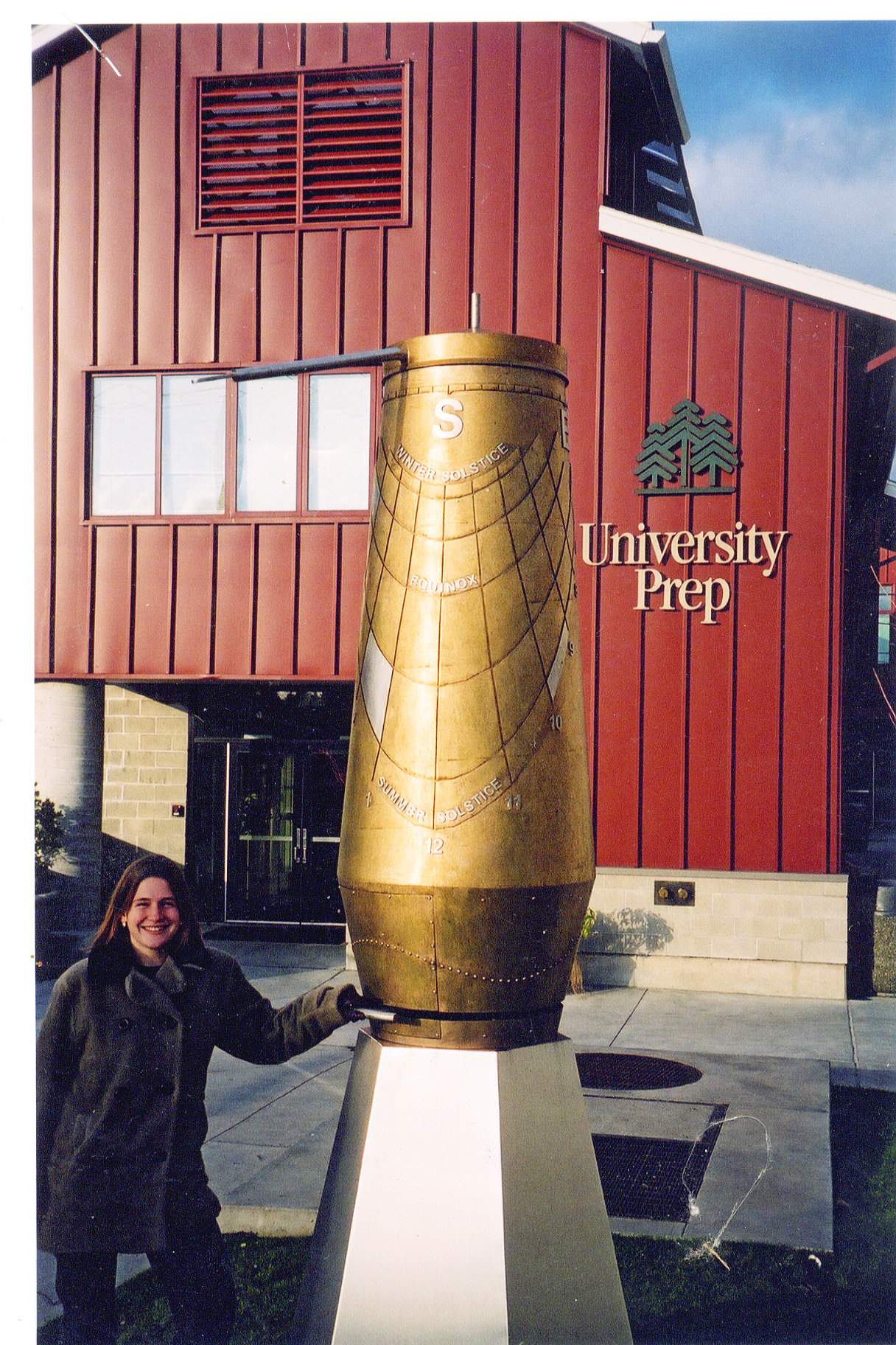 |
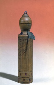
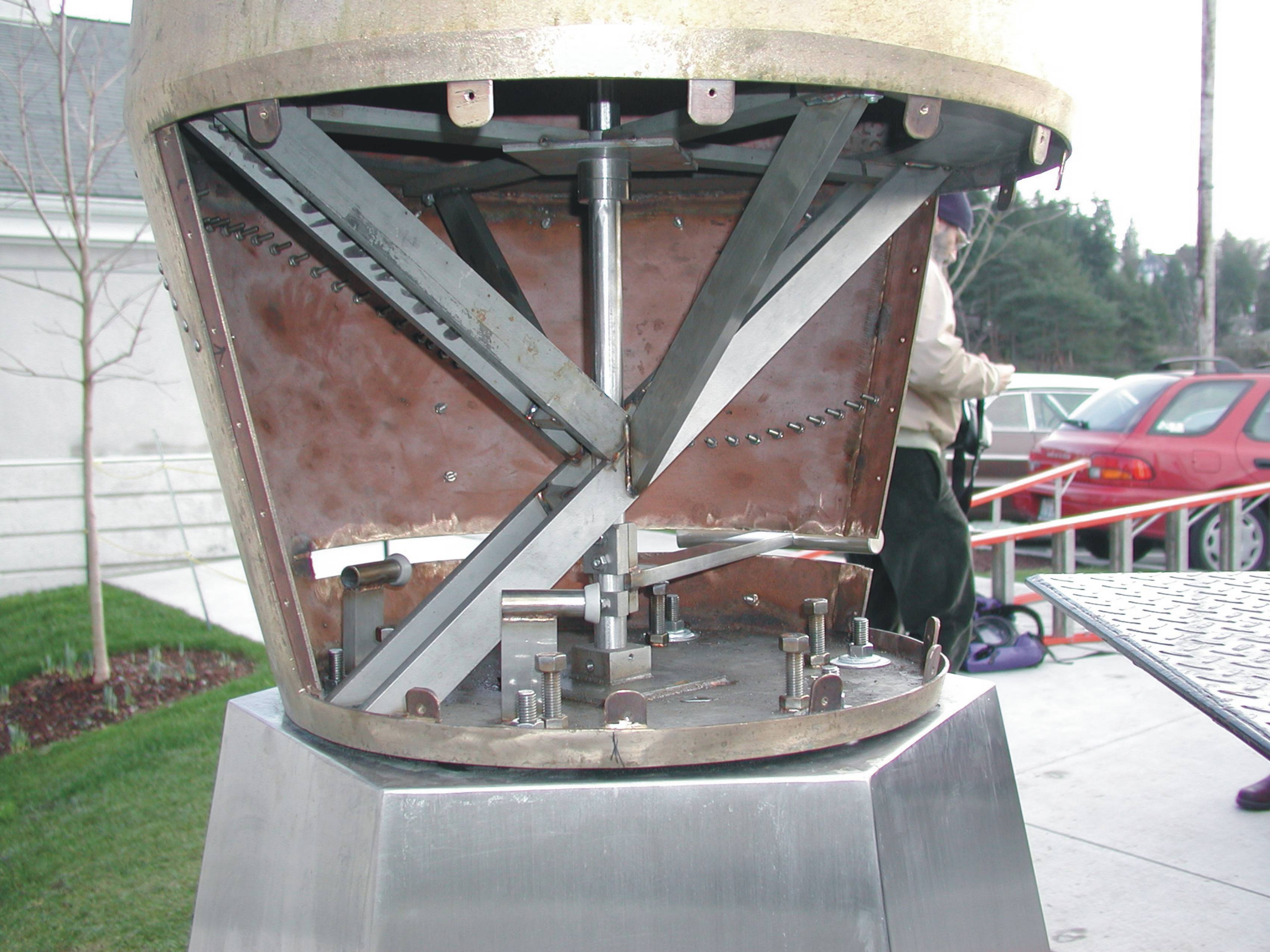
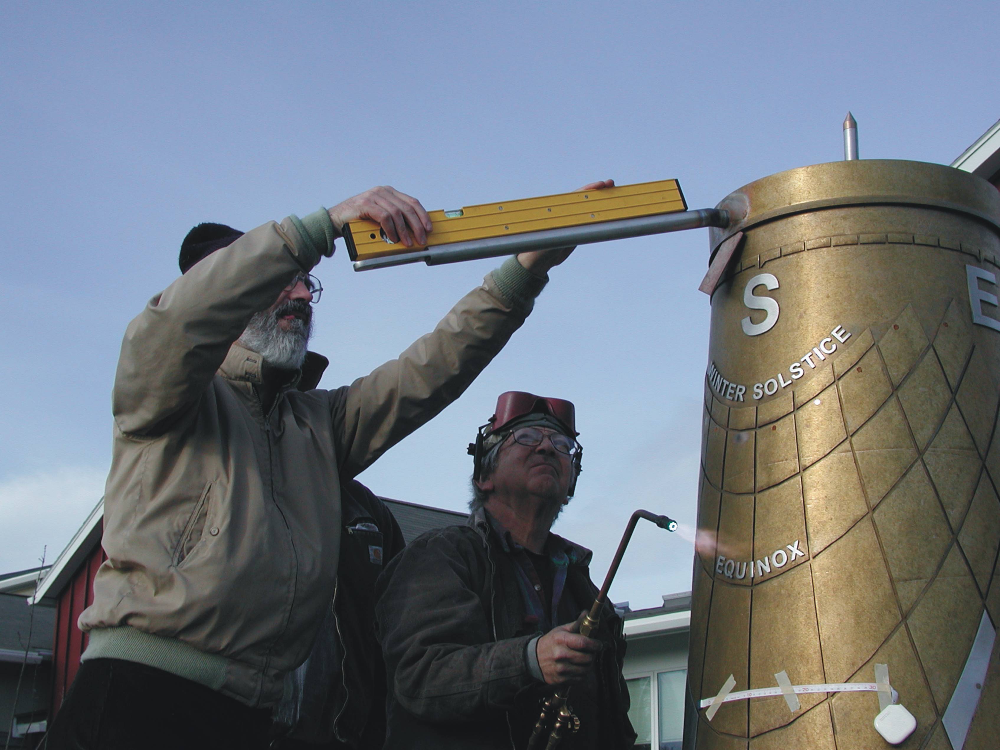
Unlike most portable sundials, this type does not need a magnetic compass for alignment because it is in effect self-aligning. Sullivan had long wanted to make a large version of this dial and the chance came when Ray Monnant, father of two boys at University Prep School, led an effort to organize and raise the funds for this project. Art teacher Peggy Dow also contributed, and Charles Wiemeyer was not only the fabricator, but gave artistic advice. Larry Stark designed the turning mechanism.
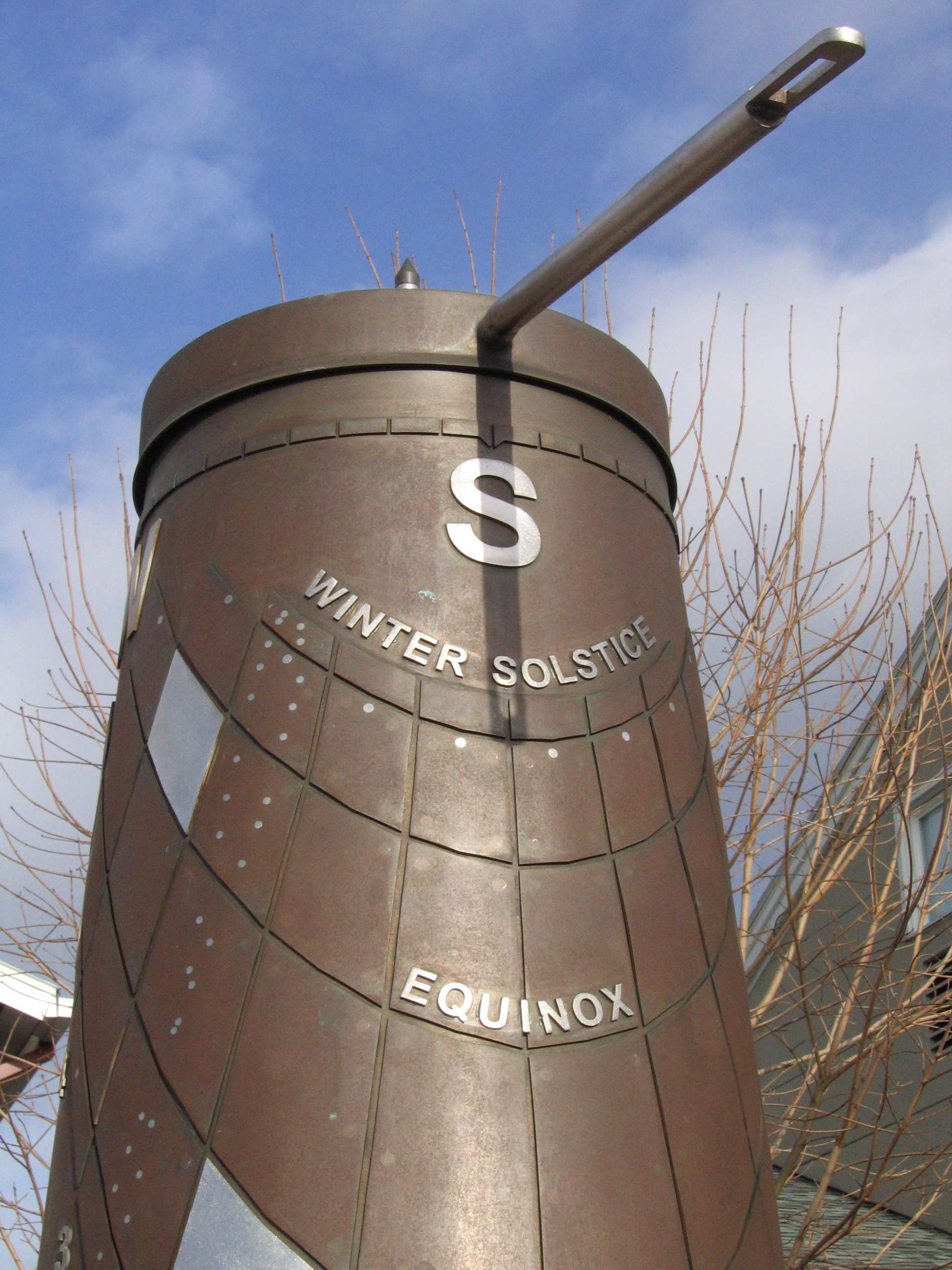 The dial is operated by turning the handle at waist height, which is
connected to the 20-inch-(50 cm)-long gnomon above, until the gnomon's
shadow falls directly downwards; the gnomon is then pointed to the azimuth
(compass direction) of the sun. One then reads the time and date from
the position of the spot of sunlight (created by a slit at the end of
the gnomon) as it falls on the side of the dial. The network of hour
and date lines has been created by attaching 60 panels to the bronze
cone; the edges of these panels define the lines. The Copernican motto
for this dial is: Who's turning?
The dial is operated by turning the handle at waist height, which is
connected to the 20-inch-(50 cm)-long gnomon above, until the gnomon's
shadow falls directly downwards; the gnomon is then pointed to the azimuth
(compass direction) of the sun. One then reads the time and date from
the position of the spot of sunlight (created by a slit at the end of
the gnomon) as it falls on the side of the dial. The network of hour
and date lines has been created by attaching 60 panels to the bronze
cone; the edges of these panels define the lines. The Copernican motto
for this dial is: Who's turning?
In a portable pillar dial, the shape is cylindrical and the gnomon projects
horizontally, but for aesthetic reasons this scaled-up version has a
surface made from two cones and the gnomon points a bit downward. The
University Prep dial also differs from the portable version in that,
since it is fixed, we know where north is. Thus we can read not only
the time, but the date, whereas the portable version requires the user
to know the date beforehand, and then it can tell one only, say, that
the time is 2 hours different from solar noon (10 am or 2 pm solar time),
but not distinguish which one is correct!
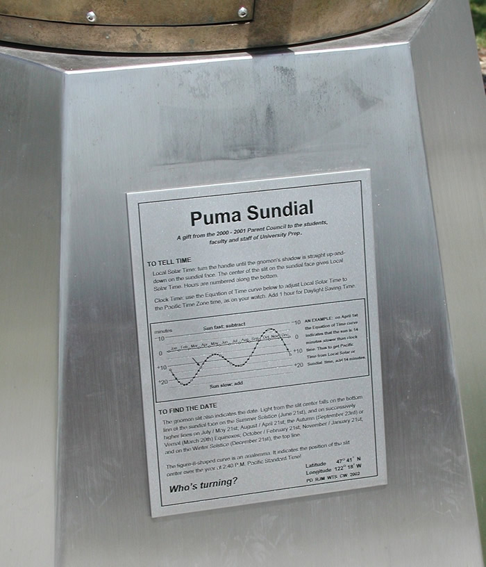
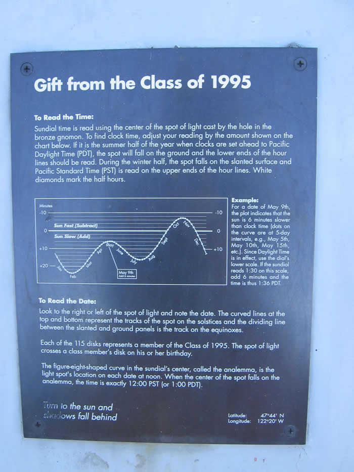
There is also much dial "furniture," including an indication of 2:40 pm Pacific Time, the time that school is out! Three of the 60 panels are made out of stainless steel; these mark the birthdays of the main designers. Tick marks at the top allow the azimuth of the sun to be read to a few degrees accuracy. The undulating line above the handle is based on the equation of time, although a more practical equation of time curve is provided on the explanatory plaque.
The north side of the dial features a puma (the school mascot) leaping through a large ellipse representing the orbit of Halley's Comet. The orbit is used as a timekeeper to indicate the date of installation as well as the founding year of the school (1976).
 |
 |
Directions: Go south 0.3 mi on 25th Ave NE and turn right onto NE 75th St. After 0.5 mi turn left at 15th Ave NE. Go about 0.7 mi and after crossing a bridge, bear right on to Cowen Pl NE; Cowen Park and the playground with the large horizontal dial are immediately on your right, about 300 ft (100 m) from the street. If you wish, take a lovely short walk in the Ravenna Creek ravine directly behind the playground. [Google Map ]
This sundial was installed as part of a general campaign to improve Cowen Park by the local neighborhood and the City of Seattle. It is situated next to a playground and kids love to shinny up the gnomon. All materials apparently were secured from Boeing Surplus. The base of the gnomon is embossed with a pattern to suggest a sunflower.
The dial is unusual in that the directions N S E W are clearly marked, but these apparently refer to magnetic North, etc., which is about 17° to the east of true North. The gnomon and the hour markers are of course aligned with true North (labelled as "Due North"). There is no plaque explaining this confusing peculiarity of a sundial having magnetic directions as a major design element. The hours are marked with tiles on a very small circle given the size of the gnomon. Accuracy of the dial is ~10-20 minutes. On the solar noon line, the positions of the summer solstice, equinoxes, and winter solstice are marked (for the shadow of the gnomon's tip). The interior of the outer circle, with the magnetic compass directions marked, is grass; outside this circle is attractive landscaping.
Just to the north of the dial are four small cast-bronze sculptures by Rachel Boughton showing the life cycle of a frog: Tadpole I, Tadpole II, Froglet, and Frog.
 Sundials
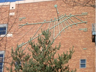
on walls are common in Europe, but relatively rare in North America.
They are usually painted on walls and often have an associated mural.
This wall dial, however, is made of pieces of metal mounted on the brick
wall (actually, through the brick wall to the concrete wall behind
it).
Sundials
on walls are common in Europe, but relatively rare in North America.
They are usually painted on walls and often have an associated mural.
This wall dial, however, is made of pieces of metal mounted on the brick
wall (actually, through the brick wall to the concrete wall behind
it).
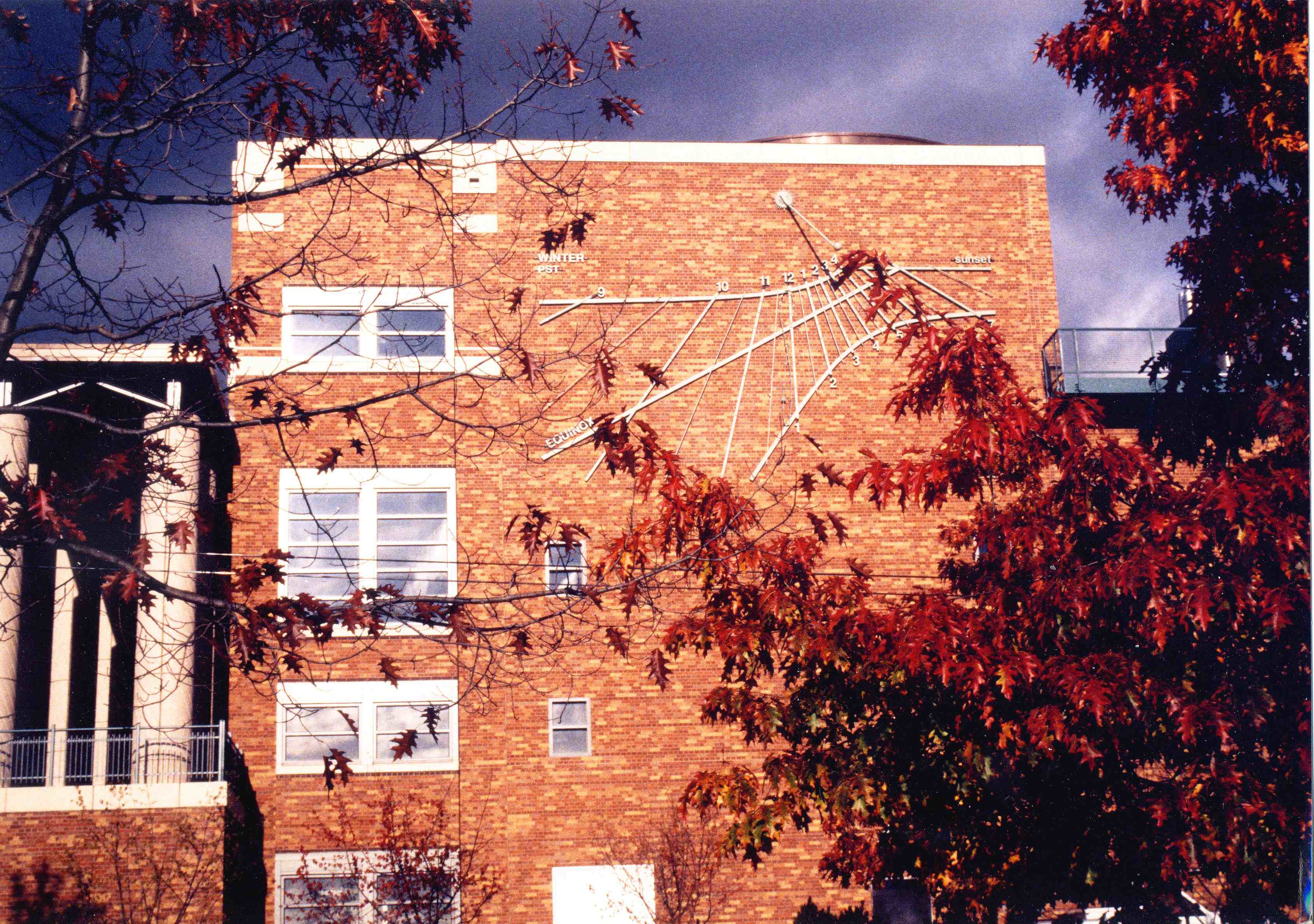
 The
initial idea for the dial came about through conversations between the
architects for the Physics/Astronomy Building and Woody Sullivan, Professor
of Astronomy. Mihaly Turbucz of Cesar Pelli's architectural firm was
the main architect involved. The dial was fabricated in the Physics
Department Instrument Shop by Larry Stark. Sullivan was in overall charge
of the project (1992-94) and did most of the design work.
The
initial idea for the dial came about through conversations between the
architects for the Physics/Astronomy Building and Woody Sullivan, Professor
of Astronomy. Mihaly Turbucz of Cesar Pelli's architectural firm was
the main architect involved. The dial was fabricated in the Physics
Department Instrument Shop by Larry Stark. Sullivan was in overall charge
of the project (1992-94) and did most of the design work.
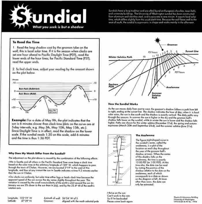
The dial's motto is What you seek is but a shadow. This was thought to be appropriate for a place of scholarship such as a university. On the other hand it was also felt that some acknowledgment should be made to the problematic aspects of a sundial located in Seattle, and so the plaque also has the ditty:
I thrive on the sun
Can't work in the rain
So if I'm beclouded
Please come back again.
Besides its large size and accuracy, the dial is also unique in that its design in fact incorporates two dial planes. The shadow of the tube should be read on the brick wall, but the shadow of the ball is designed to be read on top of the metal surfaces (about 2-3 inches (5-7 cm) from the wall). The dial also has an interesting feature to protect the gnomon from oscillations that might be set up by high winds. The tube and the ball are each half-filled with mineral oil to dampen out any oscillations that might get started. (The chance of this is small, but real - remember that the famous Tacoma Narrows Bridge disaster in 1940 happened close to here!)
Directions: If you have the time, walk the 5 minutes from the Physics/Astronomy Building to the Drumheller Fountain, also called "Frosh Pond" (ask anyone for directions, or a campus map is here ). This traditional horizontal dial is located in a flower patch by the Fountain, in the middle of Rainier Vista, a feature of the University of Washington (UW) campus that aligns with Mt. Rainier, about 50 miles away as the eagle flies. If you have further time, wander around the beautiful UW campus, especially checking out the huge, ornate Reading Room in Suzzallo Library, the cherry trees in the Quad (flowering usually in early April), and the Henry Art Gallery (contemporary art). [Google Map]
 This
dial, the second oldest extant in Seattle, was the graduating gift of
the 260 seniors in the University of Washington's Class of 1912. In
the 1911-12 Tyee (yearbook) is found (p. 19): "We leave behind
the first Senior memorial - the 1912 sun dial - as a token of what our
University has been to us and what our Alma Mater always will mean."
This
dial, the second oldest extant in Seattle, was the graduating gift of
the 260 seniors in the University of Washington's Class of 1912. In
the 1911-12 Tyee (yearbook) is found (p. 19): "We leave behind
the first Senior memorial - the 1912 sun dial - as a token of what our
University has been to us and what our Alma Mater always will mean."
During their sophomore year, the University campus was taken over by the 1909 Alaska-Yukon Exposition, many of whose buildings remained on the campus long after. The Class's official yell was:
Ho! Wa! Go! Wa!
Keep On! Keep On!
1 - 9 - 1 - 2
Washington!
The dial itself is nicely engraved with raised hour lines and roman numerals for the hours, and the basalt plinth has large letters "THE CLASS OF 1912". Unfortunately, however, the dial plate/gnomon combination is not as accurate as one would hope, being off by as much as 5-7 minutes. A ca 1910-20 postcard photo shows that the present gnomon is not the original one. In 2002 Larry Stark and Woody Sullivan made detailed measurements of the gnomon and plate, yet could not come to any conclusions as to why the hour lines and gnomon are wrong. They don't seem to be consistent for any latitude, including Seattle's! We even considered that the gnomon was incorrectly positioned on the plate, but this did not help.
A small explanatory plaque with the corrections for longitude and the equation of time is on a separate short pole in the garden. The dial's north-south alignment is noticeably discrepant from that of Rainier Vista, which is aligned with Mt. Rainier, 102 km distant at an azimuth of 154°.
1912 - the original location has not been able to be established, but a ~1910-20 postcard photo of the dial showing Denny Hall in the background indicates that it probably was not far from "Science Hall" (present Parrington Hall, built in 1902)
1952 - a photo shows it being moved, probably to a location on the site of present Red Square (see below), then a grassy area criss-crossed by pathways
1964 - article describes its location as (a) "between the library [Suzzallo] and Meany Hall [ this is old Meany Hall, located near present Henry Gallery]" and (b) "at the north end of a mall and facing the Administration Building [Gerberding Hall]" (Sunday Pictorial Magazine of Seattle Times, 27 December 1964)
ca 1970 - Red Square, new Meany Hall, Kane Hall, Odegaard Library built; dial moved to a location inside a flower bed near flag pole at south end of Memorial Way, again close to Parrington
1995 - dial cleaned by Fabrication Specialties (FS)
2002 - dial refurbished and installed in new location (fourth?) by Larry Stark, Woody Sullivan, and Kurt Kiefer (Campus Arts Administrator) at south side of Drumheller Fountain. Stainless steel base and plaque added.
 Directions: Head southeast on NE Pacific St. After 0.5 mi turn right
onto Montlake Blvd NE and continue on this road (turns into 24th Ave
E) for 0.7 mi. Montlake Branch Library (2401 24th Ave E) is on the right,
at the corner of E McGraw St. The "dial" is actually a noon mark or
meridian line inside, only viewable if the library is open, and only
"working" within an hour of solar noon (roughly 1 pm Pacific Daylight
Time). Current Library opening hours can be found here.
[Google
Map]
Directions: Head southeast on NE Pacific St. After 0.5 mi turn right
onto Montlake Blvd NE and continue on this road (turns into 24th Ave
E) for 0.7 mi. Montlake Branch Library (2401 24th Ave E) is on the right,
at the corner of E McGraw St. The "dial" is actually a noon mark or
meridian line inside, only viewable if the library is open, and only
"working" within an hour of solar noon (roughly 1 pm Pacific Daylight
Time). Current Library opening hours can be found here.
[Google
Map]
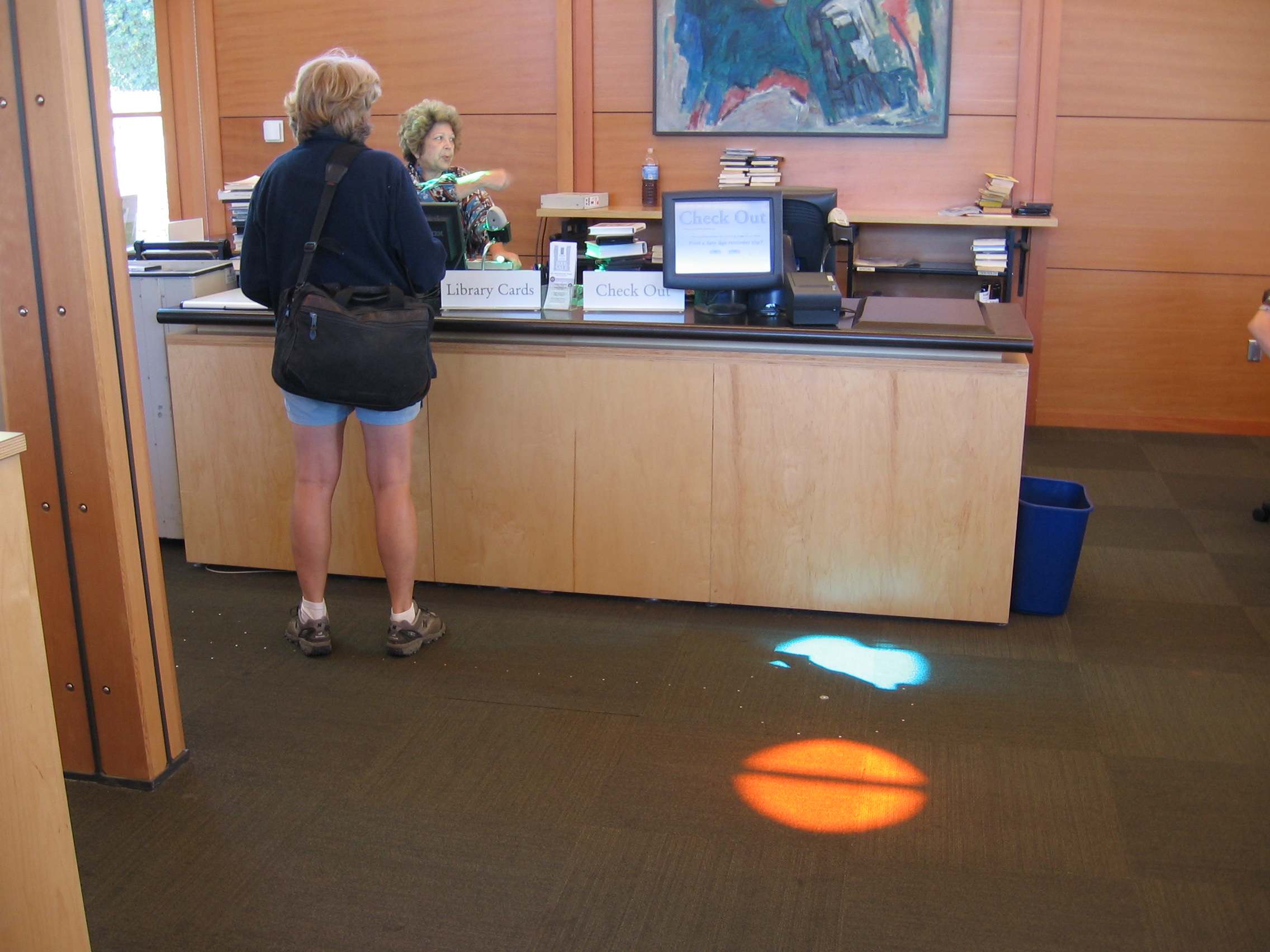
 |
 |
Five circular skylights, with colors purple, teal, green, aqua and orange, cast moving spots of light on to the floor of the main library room. The orange skylight is used for the dial, while the others are decorative. Each day at solar noon, when the sun is highest in the sky and is due south, the orange spot of sunlight aligns exactly with a north-south meridian line marked on the carpeting. The spot's position on the line varies with the seasons as the sun moves north and south through the sky. Circles are marked for the spot positions on (a) the summer solstice (about 21 June), (b) the equinoxes (about 20 March and 23 September), and (c) 12 August, the opening day for the new library in 2006.
A small brochure about the dial is available from the librarians.
Directions: Head south on 24th Ave E; after 0.9 mi, turn right onto E Aloha St. After 0.8 mi turn right onto 10th Ave E; after 0.3 mi take the second left onto E Highland Dr. The house (No. 814) is on your right after ~300 ft (100 m) with the dial plainly visible from the sidewalk. [Google Map]
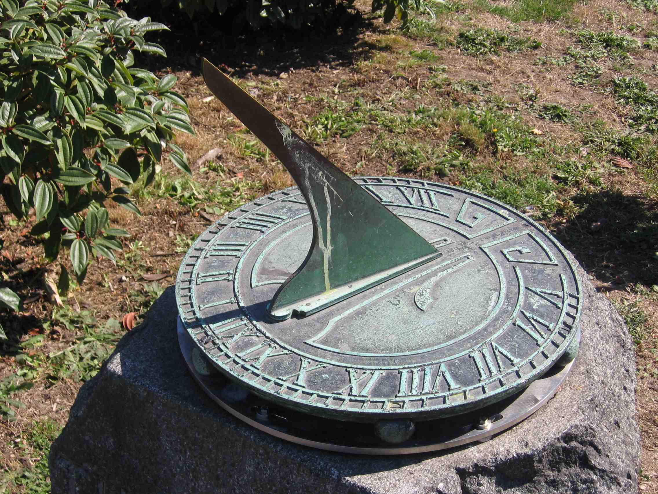
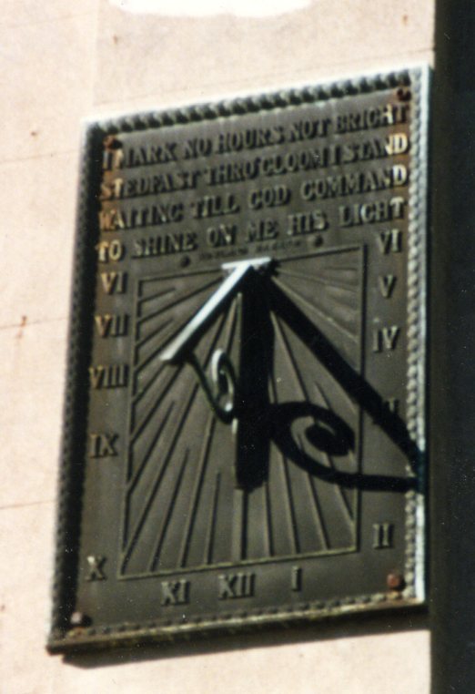 This
is the oldest extant dial in Seattle, on the venerable Sam Hill Mansion,
listed on the National Register of Historic Places. Sam Hill (1857-1931)
gained his money first by marrying the daughter of James J. Hill (no
relation), "Empire Builder" and founder of the Great Northern Railway.
Later he had many financial and business successes of his own. Although
the mansion was built to be his primary residence, in fact he didn't
live in it very much because his wife and kids lived in St. Paul, Minnesota.
Sam, meanwhile, travelled around a lot, and lived in Portland, Oregon
for most of his later days. He was eccentric and liked to build large
concrete structures - today we still have his Maryhill Mansion in Goldendale,
Washington (now a Museum of Fine Arts with a collection based on donations
from Queen Marie of Romania, with whom Sam was friends); his ersatz
"Stonehenge," also in Goldendale on bluffs overlooking the Columbia
River; and the International Peace Arch (1921) on Interstate 5 on the
Canada/USA border in Surrey/Blaine. His Seattle mansion is also heavily
concrete, on the side of a steep ravine on Capitol Hill.
This
is the oldest extant dial in Seattle, on the venerable Sam Hill Mansion,
listed on the National Register of Historic Places. Sam Hill (1857-1931)
gained his money first by marrying the daughter of James J. Hill (no
relation), "Empire Builder" and founder of the Great Northern Railway.
Later he had many financial and business successes of his own. Although
the mansion was built to be his primary residence, in fact he didn't
live in it very much because his wife and kids lived in St. Paul, Minnesota.
Sam, meanwhile, travelled around a lot, and lived in Portland, Oregon
for most of his later days. He was eccentric and liked to build large
concrete structures - today we still have his Maryhill Mansion in Goldendale,
Washington (now a Museum of Fine Arts with a collection based on donations
from Queen Marie of Romania, with whom Sam was friends); his ersatz
"Stonehenge," also in Goldendale on bluffs overlooking the Columbia
River; and the International Peace Arch (1921) on Interstate 5 on the
Canada/USA border in Surrey/Blaine. His Seattle mansion is also heavily
concrete, on the side of a steep ravine on Capitol Hill.
The sundial is sturdy, plainly designed, and not remarkable apart from its historical connection. It appears to be somehow incorrect (readings are off by as much as 20 minutes from solar time). Moreover, its motto is not even good doggerel:
I mark no hours not bright
Stedfast [sic] thru gloom I stand
Waiting till God command
To shine on me his light.
Also on the dial is the name "Rowland Hazard," an industrialist friend of Sam's, who had a similar dial on his mansion in Peace Dale, Rhode Island. The Hazard family were civic and business leaders throughout the 19th and early 20th centuries, all of the men being confusingly named Rowland, but our designer's dates were 1885-1918 and he was an executive of the Solvay Processing Co. (The designer's sister Caroline was a President of Wellesley College, and his son became one of the founders of Alcoholics Anonymous.)
According to pp. 67-9 of Alice Morse Earle's Sun-dials and Roses of Yesterday (1902), a similar Hazard sundial was installed in 1891 on the old wall of the Franciscan Mission in Santa Barbara, California.
Information: Sam Hill: The Prince of Castle Nowhere (John E. Tuhy, 1983) (see p. 105 regarding the sundial)
Sam Hill
http://www.historylink.org/index.cfm?DisplayPage=output.cfm&file_id=5072
If you have time, check out nearby Volunteer Park with its views towards Puget Sound and the Olympic Mountains, especially as seen from the marvellous abstract sculpture "Black Sun" (1969) by Isamu Noguchi. Also in the Park and well worth visiting (if you have even more time!) are the Seattle Asian Art Museum and the Conservatory. To reach the Park head back south one block on 10th Ave E, turn left on E Prospect St, again left on 15th Ave E, and find the Park entrance on your left after about 0.2 mi.
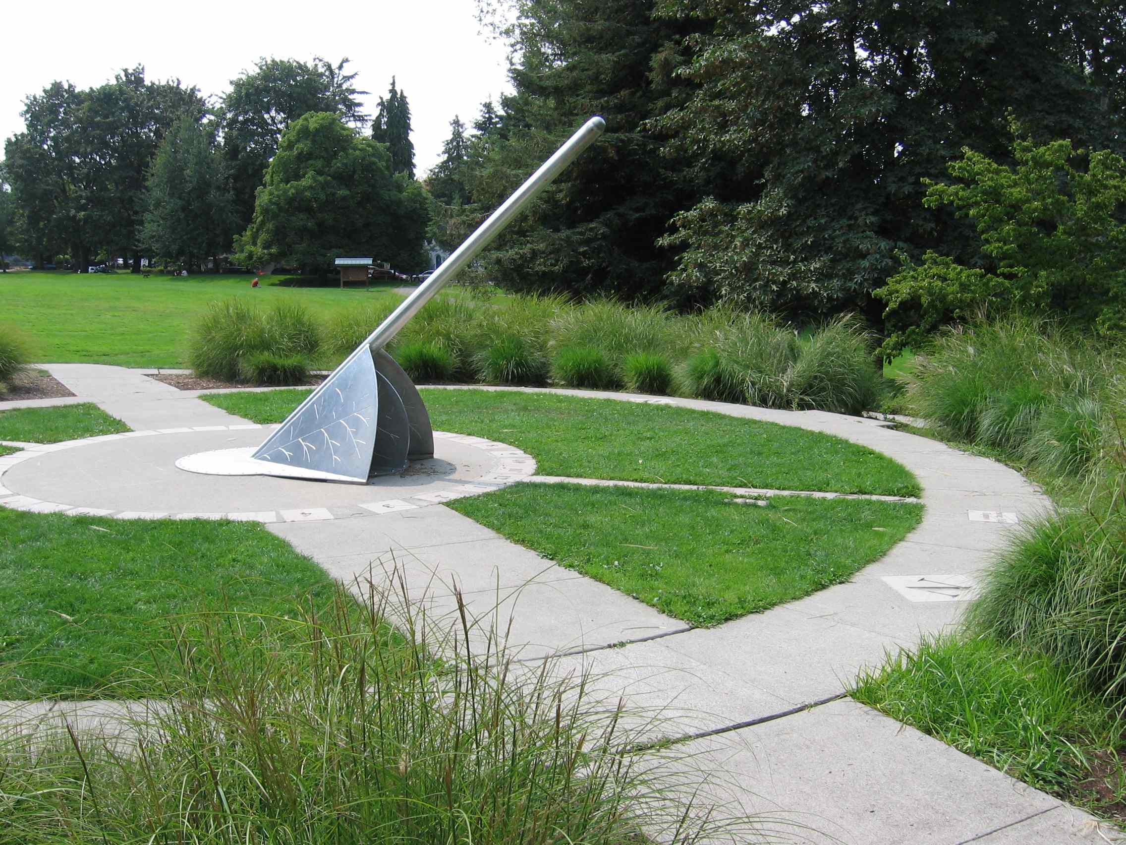
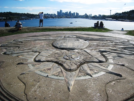
Directions: Go north on 10th Ave E for 0.9 mi and turn left onto E Roanoke St. After 0.1 mi take the second right onto Harvard Ave E, merging after 0.5 mi onto Eastlake Ave E. Once over the bridge, after 0.4 mi, exit right toward NE 40th St, circling around onto NE 40th St westbound. After 0.2 mi, come to a complex "stop-all-ways" intersection; of the two roads that go forwards, take the left one. After 0.1 mi, bear left onto NE Pacific St. After about 0.7 mi turn left onto Meridian Ave N, then right after one block onto N Northlake Way. After 0.1 mi find the Park entrance and parking lot on your left. The Park was reclaimed from an industrial site in the 1970s. The dial is on top of the prominent small, treeless hill ("Kite Hill") with a winding path. [Google Map]
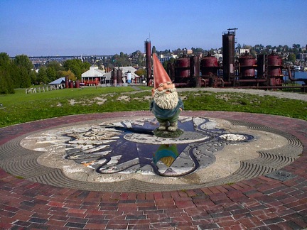 [The gnome on the gnomon is a Photoshop trick by Tom Rackers in 2005]
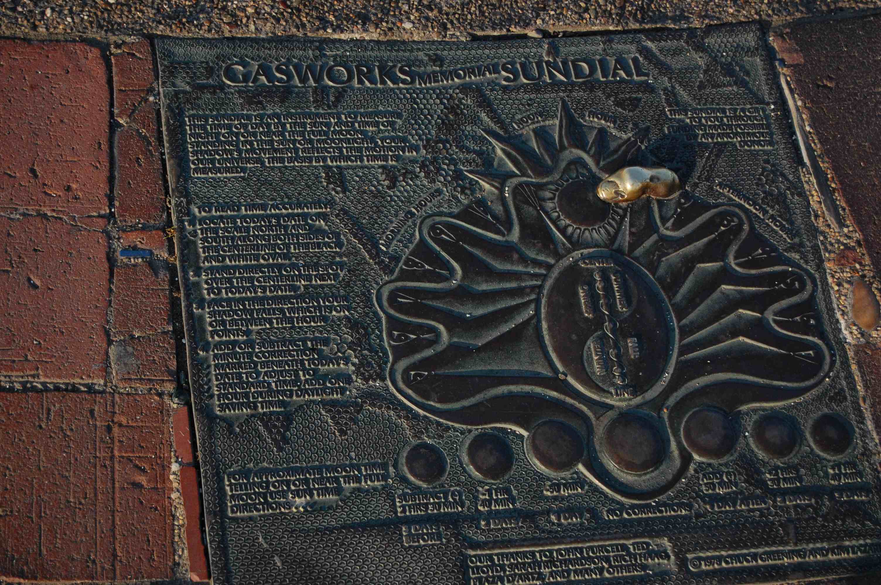
Gasworks Park is one of Seattle's most popular because of its prime location on Lake Union and its great urban views over the lake. Under the direction of Richard Haag, the site was reclaimed from a coal-to-natural-gas conversion plant, and many of the industrial structures have been retained as a reminder of that past.
On the top of a ~15-meter-high hill, great for flying kites, is an analemmatic sundial, the type where a person stands on a spot (according to the date), casting his/her own shadow and reading the time from an elliptical-shaped pattern on the ground. A bronze plaque built into the ground gives good directions for how to use the dial. As well as the dial, enjoy the scrumptious views of downtown Seattle and Lake Union, busy with sea planes, powerboats, sailboats, and rowers.
The dial's chief artist was Charles Greening (1949- ), well-known in the Northwest for many public art projects. The structure is colored concrete, with many interesting inlaid objects scattered throughout, including a bronze bear claw, a ceramic crab, pieces of pottery and glass and shells, etc. Many features are in bronze (such as some hour numerals and the line on which one stands, with a position depending on the date). Bronze casts of three pairs of footprints are those of Greening, the (anonymous) donor of the piece, and the donor's dog! There are, however, so many inlaid objects and the hour numerals are so stylized that the dial pattern is somewhat obscured.
The explanatory plaque includes information about how to read the time using the shadow of the moon (near the time of full moon). The plaque also thanks John Purcell (gnomonicist), Ted Lloys, Sarah Richardson, Rich Haag, and Plaza d'Artz
Photos and descriptions are in Art in Seattle's Public Places (J. M. Rupp, 1992) and A Field Guide to Seattle's Public Art (Seattle Arts Commission, 1991).
See http://www.fransmaes.nl/zonnewijzers/welcome-e.htm for an extremely detailed description of the dial by a Dutch sundial expert (and many close-up photos).
See http://www.vrseattle.com/pages/browse.php?cat_id=802 for panoramic photos of/from Gasworks Park, including the dial.
See http://www.larch.umd.edu/classes/larc/L160/Slides/parksplaygrounds/SLIDES34_39_45/SLIDES39_45.html for photos of Gasworks Park, including the dial.
See http://www.seattle.gov/parks/park_detail.asp?ID=293 for the official Park website, including good photos.
Directions: Head west on N Northlake Way; after 0.4 mi the road bends right and becomes Stone Way N; then immediately turn left at the light onto N 34th St. Take the third right (after 0.2 mi) onto Troll Ave and go up the hill two short blocks to N 36th St. At this intersection you will find one of the most amusing sculptures in the world: the giant Fremont Troll, lurking under a freeway bridge (Aurora Ave N) while ravishing a Volkswagen "Bug". Take a picture and resume west on N 36th St. After 0.6 mi the road bends to the right and changes name to Leary Way NW. After another 0.6 mi, turn right onto 8th Ave NW. Go 1.1 mi and turn left at NW 65th St. Go 1.4 mi and turn right at 30th Ave NW. After 0.1 mi, turn left onto NW 68th St; after one-half block park find the Nordic Heritage Museum parking lot on your left. Webster park is the very small park to its west, and the dial is easily found. If you are of Nordic Heritage or wish you were, by all means visit the Museum (information here http://www.nordicmuseum.org/ ), which celebrates the immigrant history of this portion of Seattle (Ballard). [Google Map ]
 This
dial was built as part of the neighborhood-driven creation of Webster
Park. Chuck Nafziger designed, fabricated, and installed the dial; he
was inspired by a Chinese dial he saw in an exhibit. The shadow center
of the gnomon/polar axis can be read to 1-2 minute accuracy, and the
shadow of the disk (falling on the gnomon) allows the date to be read.
Both the upper (summer half of the year) and lower (winter half) surfaces
of the disk are finely marked with one-minute divisions; this type of
dial cannot be used within about 3-5 days of the equinox because the
sun is then travelling in the (equatorial) plane and no usable shadow
is cast. The entire time scale is rotated by 9.6 minutes, in order to
compensate for the shift from PST to the local longitude, although one
still must adjust for the equation of time in order to compare with
clock time.
This
dial was built as part of the neighborhood-driven creation of Webster
Park. Chuck Nafziger designed, fabricated, and installed the dial; he
was inspired by a Chinese dial he saw in an exhibit. The shadow center
of the gnomon/polar axis can be read to 1-2 minute accuracy, and the
shadow of the disk (falling on the gnomon) allows the date to be read.
Both the upper (summer half of the year) and lower (winter half) surfaces
of the disk are finely marked with one-minute divisions; this type of
dial cannot be used within about 3-5 days of the equinox because the
sun is then travelling in the (equatorial) plane and no usable shadow
is cast. The entire time scale is rotated by 9.6 minutes, in order to
compensate for the shift from PST to the local longitude, although one
still must adjust for the equation of time in order to compare with
clock time.
There is much explanatory material incorporated into the dial's design. Other persons who contributed to the project were Virginia Lindahl, Lillian Riley, Peter Hirtle and Woody Sullivan.
Motto: "We did not inherit this land from our parents, we are borrowing it from our children"
Here you can find many photos of the dial, with tutorial links about equatorial and other types of dials.To end your full day of bagging sundials, you have two options:
Option #1 is to relax at nearby Golden Gardens Park, a small beach on Puget Sound that is ideal for watching the sun set behind the Olympic Mountains. If you'd like to splurge on a seafood dinner, Ray's Boathouse restaurant (~1.3 mi south of the Park at 6049 Seaview Ave NW) is a first-class choice with nice views of the water. To reach Golden Gardens Park from Webster Park, head west on NW 67th St and turn right at 32nd Ave NW. After 1.0 mi, the road's name changes to Golden Gardens Dr NW, whereupon it winds and wends its way down another 0.6 mi to the Park.
Option #2 is to end the day at Green Lake Park, Seattle's most popular, visiting one more dial along the way.
Directions (2.5 mi total): From the Webster Park dial, head a half-block west and turn right onto 32nd Ave NW. Go 0.7 mi and turn right at NW 80th St. Go 1.8 mi and, just after crossing Third Ave NW, the school is on the left (144 NW 80th St). The dial is adjacent to the small parking lot, at the gate to the playground. [Google Map]
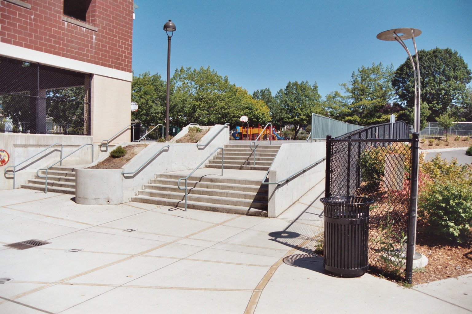
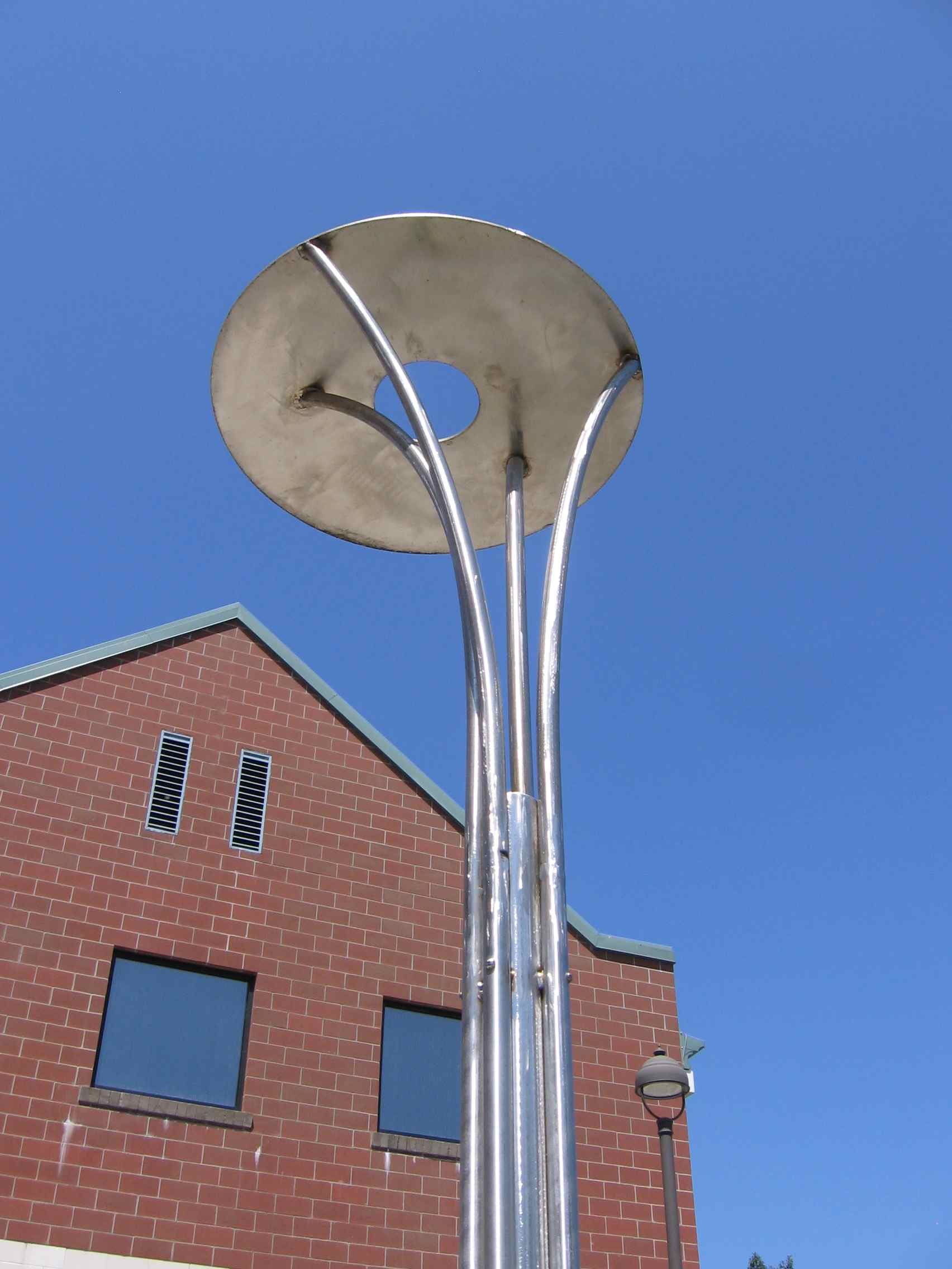 Rather than the usual gnomon for a horizontal dial, this sundial has
a nodus, meaning a reference point (in this case an aperture),
that casts a spot of sunlight on to the concrete surface of the area
outside the school entrance. The nodus is a 6 inch (15 cm) diameter
hole in a 24 inch (60 cm) diameter horizontal disk held at a height
of 10 ft 10 inches (3.30 m) by a stainless steel pole. This creates
a moving spot of light (which is surprisingly always circular in shape)
that tells the time and allows the date to be estimated, too. The solstices
and equinox lines, as well as the hour lines, are defined by color-stained
concrete strips. The pattern area is extremely irregular in shape (defined
by the building, exterior stairs, etc.), but the equinox line was made
such that it proceeds directly into the center of the school doors.
Rather than the usual gnomon for a horizontal dial, this sundial has
a nodus, meaning a reference point (in this case an aperture),
that casts a spot of sunlight on to the concrete surface of the area
outside the school entrance. The nodus is a 6 inch (15 cm) diameter
hole in a 24 inch (60 cm) diameter horizontal disk held at a height
of 10 ft 10 inches (3.30 m) by a stainless steel pole. This creates
a moving spot of light (which is surprisingly always circular in shape)
that tells the time and allows the date to be estimated, too. The solstices
and equinox lines, as well as the hour lines, are defined by color-stained
concrete strips. The pattern area is extremely irregular in shape (defined
by the building, exterior stairs, etc.), but the equinox line was made
such that it proceeds directly into the center of the school doors.
This dial was part of a renovation (completed in 2002) of the school, which dates back to 1909. It grew out of the fact that Larry Stark's daughter Ruth was a student at the school and Woody Sullivan worked on astronomy topics with fourth-grade teacher Pat Kemp in the 2000-01 school year. It works well (~5 minutes accuracy), but, as the photos show, also illustrates a classic example of a communications screw-up in a large construction project. Sullivan and Stark worked well with the project architects and construction team, but never learned that there was to be a security chain-link fence placed between the pole and the dial pattern! This ruins the aesthetics of the dial and means that when the sun is highest near the summer solstice the shadow of the fence interferes with the spot of sunlight (but at least the fence is not a wall!).
 |
 |
Green Lake Park is a further 2-mile drive to the west (back towards Interstate 5). There you can find many restaurants for various tastes and budgets, and/or take a stroll or rent a bike or roller blades to circumnavigate the 2.8 miles around the lake.
Directions: Go east on NW 80th St for 0.9 mi; turn right onto Green Lake Dr N. After only 0.1 mi, turn left at East Green Lake Dr N and go 0.5 mi along the lake; at the light where Latona Ave NE goes to the left, turn right into a parking lot (or find parking elsewhere around the lake); many restaurants extend from the spot where you entered East Green Lake Dr N to about 0.4 mi after the parking lot.
The designer of this tour (Woody Sullivan) lives near Green Lake. If you'd like to stop at my home and talk sundials, please telephone 206-784-1052 and see if I'm home! In any case please send me feedback after you've followed all or part of the Seattle Sundial Trail: woody [AT] astro dot washington
 Within
the boundaries of Seattle are some 20 sundials, the oldest from 1909
and the latest from 2006. They represent many different types, materials,
and artistic styles, not just the usual horizontal type with a gnomon
jutting upwards. This Seattle Sundial Trail includes eight of the best
dials, and will take you to many parks and school campuses, and further
provide marvellous views of the mountains and water for which Seattle
is renowned. Possible tourist activities are also suggested along the
Trail, including two iconic public sculptures. Seattle is famous for
its clouds and rain, which is why the natives appreciate the sun and
sundials all the more. To optimize your chances for actual sunshine
and shadows, follow the Trail in May through September. But rain or
shine, there is a delicious irony in Seattle being well on its way to
becoming the Sundial Capital of North America.
Within
the boundaries of Seattle are some 20 sundials, the oldest from 1909
and the latest from 2006. They represent many different types, materials,
and artistic styles, not just the usual horizontal type with a gnomon
jutting upwards. This Seattle Sundial Trail includes eight of the best
dials, and will take you to many parks and school campuses, and further
provide marvellous views of the mountains and water for which Seattle
is renowned. Possible tourist activities are also suggested along the
Trail, including two iconic public sculptures. Seattle is famous for
its clouds and rain, which is why the natives appreciate the sun and
sundials all the more. To optimize your chances for actual sunshine
and shadows, follow the Trail in May through September. But rain or
shine, there is a delicious irony in Seattle being well on its way to
becoming the Sundial Capital of North America. 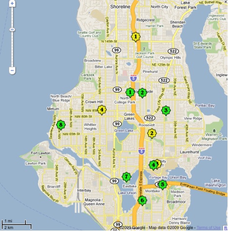 You can of course use this Google Map in all the usual ways to get directions
(including street views that often include the dials), distances, satellite
views, nearest pizza parlors, etc. Navigating around Seattle is greatly
aided by its rectangular grid with Streets running east-west and Avenues
north-south, but of course there are exceptions, bodies of water, ravines,
etc. that sometimes make it challenging. The dials are color-coded into
two groups. The 8 green dials (numbered G1 through G8 in this text)
constitute the basic Trail; there are also 4 optional yellow ones (Y1
through Y4). For the locations and linked descriptions of all
20 sundials in Seattle, see the Google Map "Seattle Sundials".
You can of course use this Google Map in all the usual ways to get directions
(including street views that often include the dials), distances, satellite
views, nearest pizza parlors, etc. Navigating around Seattle is greatly
aided by its rectangular grid with Streets running east-west and Avenues
north-south, but of course there are exceptions, bodies of water, ravines,
etc. that sometimes make it challenging. The dials are color-coded into
two groups. The 8 green dials (numbered G1 through G8 in this text)
constitute the basic Trail; there are also 4 optional yellow ones (Y1
through Y4). For the locations and linked descriptions of all
20 sundials in Seattle, see the Google Map "Seattle Sundials". 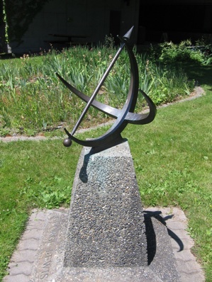 Directions:
Whether driving north or south on Interstate 5, take Exit 172 for N 85th
St, heading west toward Aurora Ave N. After about 0.5 mi, turn right at
Wallingford Ave N. After 0.4 mi turn right onto N 92nd St, then very shortly
take the first left onto College Way N. After 0.15 mi turn right on N
95th St. The dial will be on your left ~0.1 mi after turning, on the south
edge of the central plaza of the College's main building. The dial is
~90 meters (~300 ft) east of the cafeteria, in a small garden. [
Directions:
Whether driving north or south on Interstate 5, take Exit 172 for N 85th
St, heading west toward Aurora Ave N. After about 0.5 mi, turn right at
Wallingford Ave N. After 0.4 mi turn right onto N 92nd St, then very shortly
take the first left onto College Way N. After 0.15 mi turn right on N
95th St. The dial will be on your left ~0.1 mi after turning, on the south
edge of the central plaza of the College's main building. The dial is
~90 meters (~300 ft) east of the cafeteria, in a small garden. [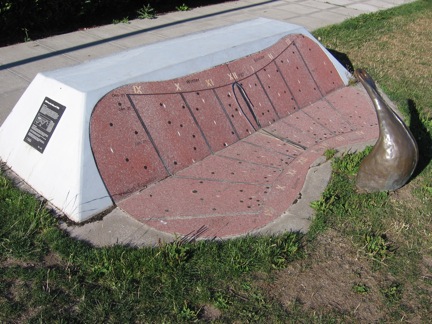
 Directions:
From College Way N, turn left at N 92nd St. After 0.6 mi turn left onto
5th Ave NE. Turn right after 0.1 mi onto NE 95th St; the school and
large dial on its south-facing wall are easily seen on the left after
0.2 mi. [
Directions:
From College Way N, turn left at N 92nd St. After 0.6 mi turn left onto
5th Ave NE. Turn right after 0.1 mi onto NE 95th St; the school and
large dial on its south-facing wall are easily seen on the left after
0.2 mi. [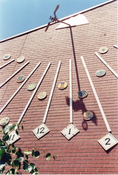 The
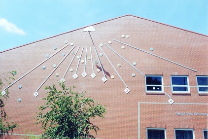
5-ft (1.5 m)-long gnomon emerges from a mountain range profile and consists
of a swooping stainless steel eagle (the school mascot with a 30-inch
(75 cm) wingspan) holding an "orb" in its beak; the orb comprises two
perpendicular rings of 4.5-inch (11 cm) diameter. One reads the time
and estimates the date from the position of the orb's shadow (see the
close-up photo). The shape of the shadow of the eagle's wings changes
throughout the day. Each of the 29 children in the class made a design
on a 8-inch (20-cm) diameter ceramic plate that was appropriate to the
season of their birthday. The plates were then placed on the wall such
that the shadow of the eagle's orb crosses each child's plate on his/her
birthday. Thus the viewer sees winter-themed plates near the top of
the dial pattern (the winter sun is low, so the shadow on the wall is
high) and summer near the bottom, with a mixture of spring and autumn
in the central portion. The large diamonds for the hour numerals were
also originally ceramic, but in 2007 were replaced with stainless steel
numerals.
The
5-ft (1.5 m)-long gnomon emerges from a mountain range profile and consists
of a swooping stainless steel eagle (the school mascot with a 30-inch
(75 cm) wingspan) holding an "orb" in its beak; the orb comprises two
perpendicular rings of 4.5-inch (11 cm) diameter. One reads the time
and estimates the date from the position of the orb's shadow (see the
close-up photo). The shape of the shadow of the eagle's wings changes
throughout the day. Each of the 29 children in the class made a design
on a 8-inch (20-cm) diameter ceramic plate that was appropriate to the
season of their birthday. The plates were then placed on the wall such
that the shadow of the eagle's orb crosses each child's plate on his/her
birthday. Thus the viewer sees winter-themed plates near the top of
the dial pattern (the winter sun is low, so the shadow on the wall is
high) and summer near the bottom, with a mixture of spring and autumn
in the central portion. The large diamonds for the hour numerals were
also originally ceramic, but in 2007 were replaced with stainless steel
numerals. 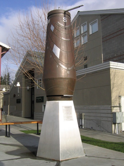 Directions:
Head east on NE 95th St; after 0.2 mi, turn right onto Roosevelt Way
NE. After 1.0 mi turn left at NE 75th St. After 0.8 mi turn left onto
25th Ave NE. After 0.3 mi turn right onto NE 80th St. Main entrance
to the school is on your left, with the dial (a ~3 meter (10 ft) tall
bronze structure) in front. [
Directions:
Head east on NE 95th St; after 0.2 mi, turn right onto Roosevelt Way
NE. After 1.0 mi turn left at NE 75th St. After 0.8 mi turn left onto
25th Ave NE. After 0.3 mi turn right onto NE 80th St. Main entrance
to the school is on your left, with the dial (a ~3 meter (10 ft) tall
bronze structure) in front. [