 |
 |
 |
| For a full overview click here |
|---|
The City of London sundial trail |
| |
|
|
|
CONDUCTED SUNDIAL TOURS IN LONDON
If you would like a guided walk to view some of the London sundials please contact Judy Stephenson or Tim Kidd |
| We have suggested a route which you can start or finish at any point. You can do a mixture of walking and public transport, just as you like. We strongly suggest you get an A to Z of Central London as maps shown are reasonable but generally to guide you rather than show detail. You should allow most of the day for the trip as you will no doubt be distracted by the numerous shops, attractions, cafes and resturants you will encounter on route. Noted at the end is an option to visit Fournier St Mosque. This is an interesting dial on an historic building. There are several pointsw where you could divert to this dial Moorgate and Tower Hill being two points Take binoculars, a compass may be useful and buy a one Day Underground Travelcard for Zone 1 & 2. You can also use this ticket on the buses. You will need permission to photograph sundials on private property. Some of the dials will require permission to enter private property or have restricted times for access, especially some of those on interesting diversions from the main track. The Thames Side Sundial Trail includes some of the City sundials and overlaps at the Tower. We heartily recommend that you also try the Thames trail route. Click here for a streetmap of the first section of this trail Start the walk at Embankment Station. Exit towards the river. From the Underground Station turn left along Victoria Embankment. Walk along a very pleasant 200m pathway to Embankment Gardens at the back of the Savoy Hotel. You will pass six splendid memorials including those to the Imperial Camel Corps, Robert Burns, Rakes (Sunday schools) and Sullivan. In the gardens you will see the SAVOY HOTEL EQUATORIAL DIAL This superb modern stainless steel Equatorial Armillary Dial was designed and made by Christopher St Daniel and Brockbrae. 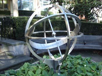 It is set in a rounded rectangular flower container. On one side of this
is the following inscription: “This garden was given to London by
the Savoy Hotel in celebration of its centenary” On the other sides
are inscriptions commemorating various illustrious people connected with
both the Savoy Hotel and the D’Oyley Carte company from 1889-1989.
The Coat of Arms of the Savoy Hotel is also inscribed. On the metal work
is engraved the wording “Savoy Centenary 1989- For Excellence we
Strive, and Every Season has its cheer - Life is lovely all the year.”
It is set in a rounded rectangular flower container. On one side of this
is the following inscription: “This garden was given to London by
the Savoy Hotel in celebration of its centenary” On the other sides
are inscriptions commemorating various illustrious people connected with
both the Savoy Hotel and the D’Oyley Carte company from 1889-1989.
The Coat of Arms of the Savoy Hotel is also inscribed. On the metal work
is engraved the wording “Savoy Centenary 1989- For Excellence we
Strive, and Every Season has its cheer - Life is lovely all the year.”
Turn left onto Victoria Embankment, and bear left into Temple Place. Left again and walk up Arundel Street to St Clement Danes Church facing you on island in the Strand. ST CLEMENT DANES CHURCH ,STRAND 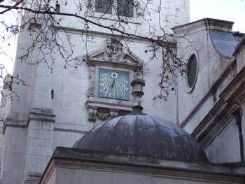 Predating
the Norman Conquest (1066), and rebuilt by Christopher Wren after the
Great Fire, this church was damaged again during the Blitz of World War
2, when the walls and the elegant tower by James Gibbs survived. Predating
the Norman Conquest (1066), and rebuilt by Christopher Wren after the
Great Fire, this church was damaged again during the Blitz of World War
2, when the walls and the elegant tower by James Gibbs survived. High up on the south face of the tower there is a large 1 metre, vertical declining sundial which has been recently restored. This church is famous for its peal of bells, and the nursery rhyme “ Oranges and Lemons, Say the bells of St Clements”. This attribution has been disputed. The clock of St Clements was designed to strike the hours twice, once on the big bell and once on the small bell. Just in case this was not enough there were originally sundials on the south and the west faces of the tower. The story goes that a payment of £1 15s 0d was made to Mr Wyn, Mathematician, for “designing two sunndyals on the Church wall”. Return to the south side of the Strand, walk east to the second turning and turn right into Essex Street. Turn left at the Edgar Wallace pub into Devereux Court and through the big gates into the Middle Temple and New Court. Turn right towards the fountain ahead and left into FOUNTAIN COURT. ESSEX COURT DIAL ( is in fact in Fountain Court ) 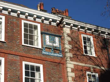 Since this vertical declining dial was placed on the wall of Brick Court
opposite the Middle Temple Hall in 1685, the plane trees have grown so
tall as to almost obscure the sun. It is made of stone, beautifully maintained
and has the motto 'Discite Justitium Moniti' or 'Learn justice you who
are now being instructed'.
Since this vertical declining dial was placed on the wall of Brick Court
opposite the Middle Temple Hall in 1685, the plane trees have grown so
tall as to almost obscure the sun. It is made of stone, beautifully maintained
and has the motto 'Discite Justitium Moniti' or 'Learn justice you who
are now being instructed'. Return to the fountain and walk South down the flight of steps into Garden Court, towards Middle Temple Gardens. If these are closed you will still get a restricted view of a horizontal dial in the distance. Middle Temple Gardens are open to the public on weekdays 12-3 in May, June July September. MIDDLE TEMPLE GARDENS DIAL 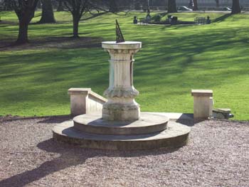 This is a horizontal dial around 1830 in excellent condition around 380
mm diameter.
This is a horizontal dial around 1830 in excellent condition around 380
mm diameter. Return to Fountain Court and turn left up Middle Temple Lane. Turn right into arch signed towards Pump Court. MIDDLE TEMPLE, PUMP COURT 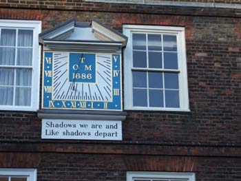 This is a sister dial to the Essex Court Dial; another stone vertical
declining dial (South 10 East) dated 1686, with the morbid motto -“Shadows
we are and like Shadows we depart”.
This is a sister dial to the Essex Court Dial; another stone vertical
declining dial (South 10 East) dated 1686, with the morbid motto -“Shadows
we are and like Shadows we depart”. Walk across Pump Court through 3 Arches into a square with Temple Church on the left, and continue through an arch into Kings Bench Walk. Turn right down Kings Bench Walk and right again, past Paper Buildings to the gardens on the left hand [south] side in Crown Office Row. Gardens open to the public 12.30 - 15.00 Mon-Fri. Public not admitted unless accompanied by a member of the Inner Temple. Maybe you will be as lucky as we were. We went into the Treasury Office sign posted in Crown Office row and asked permission to go into the gardens to see the sundials. Permission was readily given. CROWN OFFICE WALK HORIZONTAL DIAL  This horizontal sundial is made of metal on a stone plinth, and is in
very good condition. It has an ornate gnomon, with Pegasus and the initials
TRP on it. It is dated on the gnomon 1707.
This horizontal sundial is made of metal on a stone plinth, and is in
very good condition. It has an ornate gnomon, with Pegasus and the initials
TRP on it. It is dated on the gnomon 1707. 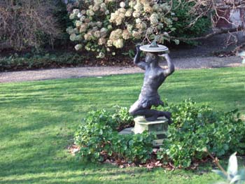
INNER TEMPLE Kings Bench Walk You can see this dial clearly through the railings, although there is no general public access to these gardens. It is worth a look for its odd plinth. A crouching statue of a black boy holds a horizontal dial on his head. The gnomon is dated 1886, and the maker is Newton & Co 3 Fleet Street. The date on the gnomon base is 1731. The dial and the statue are not of the same date and have been assembled at some time unknown. Two similar statues exist in Manchester and Cheshire and are believed to be part of a set of five. Leave the Temple through Mitre Court onto the Strand. Walk or take the bus up Fleet St. Cross over Ludgate Circus onto Ludgate Hill. Turn left into Ave Maria Lane. If you do not have permission to see this next dial, turn left from Ludgate Hill into Old Bailey and walk up to the next main junction with Newgate. Rejoin the route instuctions below at St Sepulchre. Click here for a streetmap of this section of this trail ST. PAULS AMEN COURT 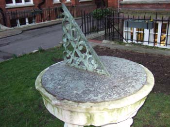 You need permission before you can enter this private court, which
belongs to the Chapter of St Paul's Cathedral. Permission may be obtained
from the secretary to the Clerk of Works (020 7236 4128). Follow the road
inside the gates to a small green where the sundial stands in the middle.
This court is occupied by clergy and staff attached to the Cathedral
and is a surprising little residential area in the middle of the square
mile. Amen Court and Ave Maria Lane both take their names from words recited
by clergy in their litanies on procession around the medieval cathedral.
You need permission before you can enter this private court, which
belongs to the Chapter of St Paul's Cathedral. Permission may be obtained
from the secretary to the Clerk of Works (020 7236 4128). Follow the road
inside the gates to a small green where the sundial stands in the middle.
This court is occupied by clergy and staff attached to the Cathedral
and is a surprising little residential area in the middle of the square
mile. Amen Court and Ave Maria Lane both take their names from words recited
by clergy in their litanies on procession around the medieval cathedral.
The horizontal eighteenth-century dial is attributed to Christopher Wren and made of brass on a stone plinth. The dial plate is original, but the legs have been rotated to hide the worn parts. Of most interest in its manufacture is the design of the gnomon which bears the motif of the Deanery of St Pauls, the letter D and crossed swords. These symbols will be seen throughout the court, perhaps at their best on three fine eighteenth-century lead cisterns standing in front of the arch and (locked) gateway leading out onto the street from this side of the court. Turn left out of Amen Court. Walk up Warwick Lane to the end. Turn left into Newgate St. Walk 150m west with the imposing vermiculated rustication of the Central Criminal Court, the Old Bailey walls on your left. Cross the roads twice at the lights. On the opposite side on the corner of Snow Hill and Holborn Viaduct is : ST SEPULCHRE CHURCH WITHOUT NEWGATE This church, properly the Church of the Holy Sepulchre without Newgate, is commonly known as the church of the Old Bailey. It is the one referred to in the old nursery rhyme “When will you pay me ? Say the bells of Old Bailey “. The church, which partly dates from before the Great Fire, is one of the few in the City not rebuilt by Wren. It contains the Bells of Old Bailey including the Newgate (Old Bailey) Execution Bell and the tomb of Captain John Smith of Jamestown, famous as the founder of Virginia. 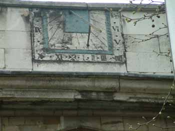 From its steps is a good view of the Old Bailey, today the Central Criminal
Court with the fine statue of justice with scales in her hands on the
top of the dome. (Test your eyesight - Is she really blindfolded??). Prior
to this building constructed in 1907 this was the site of Newgate Prison,
famous as a place outside which public executions took place until 1868.
From its steps is a good view of the Old Bailey, today the Central Criminal
Court with the fine statue of justice with scales in her hands on the
top of the dome. (Test your eyesight - Is she really blindfolded??). Prior
to this building constructed in 1907 this was the site of Newgate Prison,
famous as a place outside which public executions took place until 1868.
The dial is on the parapet above the south wall of the nave and declines 28W. The south wall of the church has a vertical declining dial dating from 1681. The church faces south-east rather than true east and the hours shown are thus 0800-1900 (winter time). The dial is of painted stone, blue and white. Retrace your route to the junction and turn left up Giltspur St. Keep to the right, walking 300 metres following the wall of St Bartholomew's Hospital as far as Smithfield, a large open area in front of the Central Markets, where London's meat is still bought and sold every night of the week. This was once the area of jousting tournaments on the medieval "smooth field". Turn right into Cloth Fair, along which are excellent views of the back of St Bartholomew's church, what is left today of the great medieval priory of St Bartholomew. Bear round into Cloth Fair right to the end. Turn left into Cloth St, right into Long Lane, up to the junction with Aldersgate St. If it’s a Wednesday afternoon(from 1415h) between April and July, you have the option to visit a very special dial. Walk North up Aldersgate Street, turn left along Carthusian St. and turn right into Charterhouse Square. Continue around the square clock-wise and in the middle of the far, north side is the entrance to the Charterhouse. THE CHARTERHOUSE (SUTTON’S HOSPITAL)  This foundation is private, and usually access is only on Wednesdays between
April 1 and July 31st at 1415h, upon purchase of a ticket (£3) for
a guided tour lasting around 90 minutes. The dial (c. 1628) is on the
south wall of the great Tudor Hall. It bears Thomas Sutton's coat of arms
and the Charterhouse colour, a vivid purple.
This foundation is private, and usually access is only on Wednesdays between
April 1 and July 31st at 1415h, upon purchase of a ticket (£3) for
a guided tour lasting around 90 minutes. The dial (c. 1628) is on the
south wall of the great Tudor Hall. It bears Thomas Sutton's coat of arms
and the Charterhouse colour, a vivid purple. This foundation takes its name from the Carthusian Monastery on the site until the reformation when the prior and many of the monks (the English Martyrs) were executed for refusing to sign the Oath of Supremacy recognising the King Henry VIII as Head of the Church. Following the dissolution of the monasteries, it passed through many hands until in 1611 Thomas Sutton "esteemed the richest commoner in England" acquired it as a school and hospital for poor gentlemen. The hospital ("Sutton's Hospital") continues to house Charterhouse Pensioners in what remain of the old buildings. From the gateway of the Charterhouse, continue clockwise around the square and turn left into Cartusian Street 100m to Aldersgate Street. Turn right (southwards) 100m and turn left into Beech Street and its continuation which is Chiswell Street, a walking distance of 450m. Unfortunately much of it along a road tunnel under the Barbican. On the left are the tall gates of: 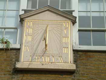 SUNDIAL COURT OF THE GUILDHALL SCHOOL OF MUSIC AND DRAMA FORMERLY THE
WHITBREAD BREWERY.
SUNDIAL COURT OF THE GUILDHALL SCHOOL OF MUSIC AND DRAMA FORMERLY THE
WHITBREAD BREWERY. This courtyard was once part of the headquarters of Whitbread brewery, but has recently become a part of the Guildhall School of Music and Drama. If the gates are open, check with security staff for permission to go closer to inspect the dial. If the gates are locked, the dial is visible 75m away from the gates against the far wall. The view from the street (preferably with binoculars) is a fine one of another superb vertical South declining dial. It is made, unusually, of wood, with its motto 'such is life', dating back to 1771. Around the sides are the legend "Built 1758, burnt 1773, rebuilt 1774. Click here for a streetmap of this section of this trail Now continue a further 400m along to the Eastern end of Chiswell street, turn right and walk 300m south along Moorgate. A large pair of clocks feature on the walls of Britannic House, headquarters for BP. High on the opposite side of the road is a fine view of Electra House, built in 1903 for Cable and Wireless but now a part of Guildhall University.. High on the roof is a large armillary sphere on top of the building which is not, as one might think, a sundial, but an emblem reflecting the task of Cable and Wireless to provide worldwide radio connections. It has echoes of similar devices developed to function as sundials. Turn left into London Wall, continue along Wormwood Street, Camomile Street, and Bevis Marks. From Bevis Marks turn right into Cree Church Lane and continue until you meet Leadenhall Street. Immediately on your left is St Katharine Cree Church The sundial is high on the wall of the church. Cross the road to get a better view. ST KATHERINE CREE HISTORIC CHURCH. 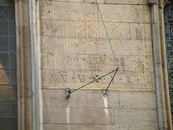 This church survived the Great Fire of London and dates from 1630 with
an extremely fine plaster ceiling inside showing the arms of many of the
City livery companies. On the street side is a vertical South Declining
rectangular dial dating from around 1700. The gnomon is rather precarious
but the face is in fair condition with gilded embellishments including
declining lines, Babylonian/Italian hours and Zodiac signs and motto "Non
Sine Lumine”. (Nothing Without Light)
This church survived the Great Fire of London and dates from 1630 with
an extremely fine plaster ceiling inside showing the arms of many of the
City livery companies. On the street side is a vertical South Declining
rectangular dial dating from around 1700. The gnomon is rather precarious
but the face is in fair condition with gilded embellishments including
declining lines, Babylonian/Italian hours and Zodiac signs and motto "Non
Sine Lumine”. (Nothing Without Light) Diagonally across from the church on the east side [to your right with your back to the church] is a small covered alleyway Fenchurch Buildings. Walk through it and it will bring you out into Fenchurch Street. Cross the road diagionally to the right and walk down Lloyds Avenue. Cross the intersection at the end, and follow Coopers Row under the arches, signposted Tower Hill. Go through Trinity Square, and, bearing to the left, go past the Underground, up the steps and onto Tower Hill where stands the large dial . Click here for a streetmap of this section of this trail TOWER HILL DIAL (over Underground Station) 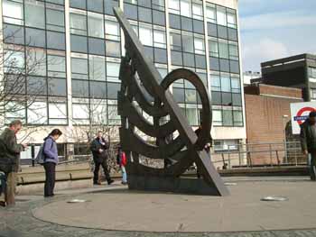 This
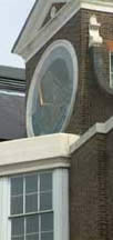
is a large and imposing horizontal dial over 6 metres in diameter. It
was constructed of bronze and stone in 1990 by John Chitty and Christopher
St Daniel. It depicts London scenes. The outer ring shows the history
of London Transport from 1066 (the conquest) to 1982 (Thames Barrier).
Shows 5am to 9pm (LAT plus 1 hour) in 15 minute intervals This
is a large and imposing horizontal dial over 6 metres in diameter. It
was constructed of bronze and stone in 1990 by John Chitty and Christopher
St Daniel. It depicts London scenes. The outer ring shows the history
of London Transport from 1066 (the conquest) to 1982 (Thames Barrier).
Shows 5am to 9pm (LAT plus 1 hour) in 15 minute intervals The Tower Hill Dial is part of the THAMES SUNDIAL TRAIL, another trail worth following and you might like to join it here. As an optional diversion you can visit St Martins Tower dial and St Katherines Dock, which are close by. Follow the pavement and railings around the north Side of the Tower of London to Tower Bridge Approach road - approx 800m. Stop at a point about 200m from Tower Bridge. Look to the right and up on the wall of the Tower. Binoculars would be useful here to get a good view as its expensive with long queues to get into Tower.
A Vertical South Rectangular Stone dial with sunburst and carvings, gilded. This 1988 dial replaces a much earlier seventeenth century dial on the same location. From the approach road take the steps down to the river side walk going East. Walk along the river side into St Katharine’s Dock (without falling into dock). ST KATHARINES DOCK DIAL 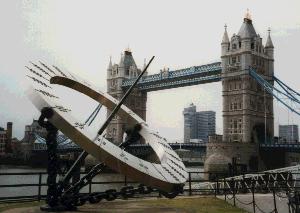 This is a large equinoctial sundial in the form of a massive, 3.66 metres, stainless steel ring supported by three rigid chain link cables. The dial was designed by Wendy Taylor in 1973 and delineated by Christopher St J Daniels Return to Tower Hill to resume the trail after this little diversion From Tower Hill turn right and cross Trinity Square Gardens. Continue into Byward Street, fork right into Great Tower Street. Turn left down St Dunstans Hill and enter St Dunstans Churchyard. ST DUNSTAN IN THE EAST 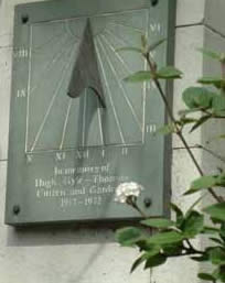 This Wren church was ruined by wartime bombing. In 1971 the remaining
graceful tower and the nave walls were incorporated into a fine little
garden. There in the lower garden and next to a fig tree planted on St
Patrick's Day 1937, the coronation day of George VI - you will find a
modern 20"x18"/ 50cm x 45cm blue/grey slate vertical south declining W
rectangular sundial, with the inscription,
This Wren church was ruined by wartime bombing. In 1971 the remaining
graceful tower and the nave walls were incorporated into a fine little
garden. There in the lower garden and next to a fig tree planted on St
Patrick's Day 1937, the coronation day of George VI - you will find a
modern 20"x18"/ 50cm x 45cm blue/grey slate vertical south declining W
rectangular sundial, with the inscription,"In memory of Hugh Gyle-Thompson Citiizen and gardener 1913-1972". If the garden is closed you can peer through the railing over the wall, if you are tall enough, or using a mirror as a periscope. Exit through the same gateway and walk round the church to St dunstan's Lane. At the end, turn up St Mary-at-Hill to the top and turn left into Eastcheap to Monument tube station. Walk up King William Street to Bank and then sharp right down Mansion House Place. Continue straight on the pavement walk - St Stephens Row, and follow the street round to the right. You will see St Stephen Walbrook Henry Moore sundial through the railings at the back of St Stephen Walbrooks Church.. The warden says there is no access to this dial because the terrace is unmaintained and dangerous. ST STEPHEN WALBROOK  This is another Wren church where in the back garden there is a fine modern
45 cm wide bowstring equatorial sundial. This is a mini replica of the
large and famous Henry Moore 18ft /5.5m tall sundial, made for the Times
newspaper and erected in 1967 outside their now non-existent premises
opposite Blackfriars Station, before being sold and shipped to Belgium.
This is another Wren church where in the back garden there is a fine modern
45 cm wide bowstring equatorial sundial. This is a mini replica of the
large and famous Henry Moore 18ft /5.5m tall sundial, made for the Times
newspaper and erected in 1967 outside their now non-existent premises
opposite Blackfriars Station, before being sold and shipped to Belgium.
The dial is well-viewed through the railings. The black marble pedestal bears an inscription to Denia Palumbo 1938-1986. She was the wife of Peter Palumbo, a local property developer, who was churchwarden of St Stephen. The motto on the dial is "I count only the sunny hours". Walk round the corner and turn left into Walbrook. Cross Cannon Street and walk straight on down Dowgate Hill, Turn right into College Street. where there is a small gardenopposite the church of St Michael Paternoster Royal, famous as the church of Dick Whittington. Half way along on the right hand side go up a small dead end alleyway with a flagpole on the corner and look up high to Pellipar House Sundial . REAR OF PELLIPAR HOUSE. 9 Cloak lane 
 Look up high to the right of the church (with Binoculars is best) to view two excellent 3.5 metre diameter circular sundials erected around 1991, one south facing and one west facing. Both are painted blue with gilded arabic (L.A.T) and Roman numerals for BST. The south facing dial bears the motto in Latin "horas non numero nisi serenas". I count none but the happy hours From here walk West along College St. Turn right up College Hill and left into Cannon St. And continue walking West pass Mansion House tube station (which is half way) on the way to Bracken House. (Between Friday St. and Distaff Lane on the South side of cannon Street). Here you see not a sundial but an unusual astronomical sundial related clock with an interesting history. 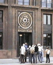 BRACKEN HOUSE
 This building (1955-1959) is named after Bernard Bracken, former chairman of the Financial Times, which was published here until the 1980s. The building was among the first post-war buildings in the City to be listed and its redevelopment retained the entire outside facade, including the elegant astronomical clock approximately 1 metre in diameter bearing at its centre a face of Winston Churchill, a personal friend of Bernard Bracken. The work of Philip Bentham in gilt metal and enamel, it has echoes of the formality and sophistication of a dial. Embellished with Roman numerals, it depicts months of the year, signs of the zodiac and a sunburst motif. Return backtracking down Cannon St. to last junction. Turn left up Bread St. Walk up Bread St. to Cheapside. Cross Cheapside to:-  114 CHEAPSIDE (currently a British Telecom shop at street level) part
of the Sun Life insurance building.
114 CHEAPSIDE (currently a British Telecom shop at street level) part
of the Sun Life insurance building. Here on the corner are two vertical stone sundials, one west declining and the other south declining with gold sunburst attributed to Professio J Skeaping, which were erected in 1958 when this post-war building was constructed for Sun Life. Of all the time pieces in Cheapside which show varying times, these 2 are reckoned by some to be the most reliable. After visiting, you might want to extend your trip with a visit to the Clock museum nearby, as a perfect end to your walk. To reach the Clock Museum pass though the passageway by 114 Cheapside passing into Milk Street and walk north up Milk Street and cross over into Aldermanbury to visit the Clock Museum just along Aldermanbury (open Monday to Friday 0900 to 1700). This also exhibits a large brass horizontal sundial c 1650 attributed to Elias Allen, Master of the Grocers Company and later of the Clockmakers Company. Both of these Companies were charged, in their time, to scrutinize and pass goods as worthy or reject and destroy substandard products. Thank you for joining us. Have a nice day and do try the Thames Trail if you have not already tried it. Optional Diversion to Fournier St Time and energy permitting, make an effort if possible to visit just one more historic dial in nearby Tower Hamlets. This is well worth the effort and is mentioned because of the history of the dial and the place. Take the tube to Aldgate East. From the same side of the road as the church either-catch a no 25 bus if it is running that day, or walk eastwards for about 600m along Whitechapel High Street to the junction with Commercial Street, Then either catch a 67 bus or walk another 600m for 5 streets to FOURNIER STREET MOSQUE 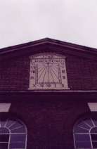 This building has been a church, a synagogue and now a mosque. The particular
significance of this listed monument building is that is gives us a prime
palimpsest for the history of this part of London.
This building has been a church, a synagogue and now a mosque. The particular
significance of this listed monument building is that is gives us a prime
palimpsest for the history of this part of London. Built as a Huguenot chapel in 1742, it became a Methodist chapel in 1809 and a synagogue in 1897 - known as the Machzieki Hadass and Great Spitalfields Synagogue. In the 1970s it became a mosque. The sundial has remained to count the hours through the changing populations of the East End of London. High up on the wall of the Majid Mosque there is a lovely large vertical south facing stone and iron sundial dated 1743 with the motto "Umbra Sumus". Contributers to this trail have been Katherine Hallgarten, Peter Tompkins, Irene and Kevin Barrett, Max and Ruth Wiseman, Martin Hinchcliffe, Graham Stapleton and also Leonard Honey, Jo Darke, Martin Birdseye |
|
|
|---|
| This complete website © Internetworks, 1997-2007. The site was designed and is maintained by Internetworks Ltd of Epsom, England |
| last revision |
| Comments/ suggestions/ problems, please get in touch with the Webmaster |