 For
a full overview click here
For
a full overview click here For
a full overview click here Houston sundial trail |
|---|
|
This tour of Houston area sundials provides a one day excursion through the city to visit points that have cultural interest as well as providing a glimpse of seven unusual public sundials that capture the hearts and minds of so many Houstonians. The 62 mile long tour takes approximately 5 hours to complete. Additional side trips to another seven dials are also provided to fit your travel itinerary and time. All driving directions are given in italics font. 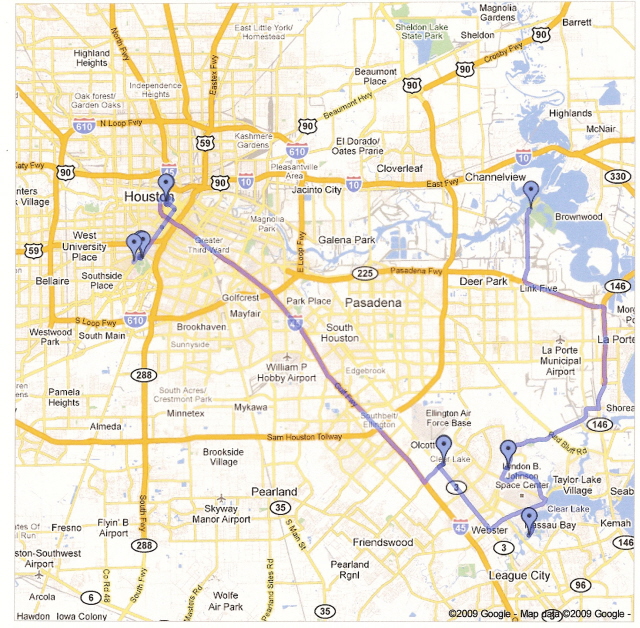
Houston is a driving town. Due to the distances between dial sites, an automobile is required. The tour starts on the Rice University campus. For those not familiar with Houston, there are two expressways that ring the city, I-610, and Beltway 8 (also called Sam Houston toll road). US-59 bisects both circle expressways and passes through the heart of the city. When on US-59, take the Main Street exit and turn south. Or, if downtown, head south on main street; turn left 1.4 miles from the US-59/Main Street intersection, which is the second entrance to the Rice University campus; park in the Founder's Court visitor lot on the left. The first dial is on the western side of the parking lot in front of the Cohen House. 1. Cohen House Sundial The sundial is a 28 inch equatorial, or "bowstring" dial, with the Rice University crest mounted at the center of the polar axis. A hole in the movable crest allows the sun to precisely indicate the time, marked in 20 minute intervals. The dial face also includes solstice, equinox, and zodiac symbols. The equation of time is interposed on top of the dateline. The flanks of the dial show time of sunrise and sunset. Returning to your car, turn left onto Main Street. Proceed 0.4 miles and turn right onto Herman Loop Drive, cross Fannin Street, and you will find yourself at the entrance of Herman Park. Proceed around the statue of Sam Houston. The Houston Museum of Natural Science is immediately on the left side (total distance of 0.6 miles from Rice University). Park on the street or in the museum parking garage.
2. Virginia and Ernest Cockrell, Jr. Memorial Sundial The Herman Memorial Park contains 285 acres of green space in the middle of Houston. It houses the city zoo, Japanese garden, rose garden, and the Miller Outdoor Theater for the performing arts. You may easily spend several days in this park alone. The Houston Museum of Natural Science houses a rich array of natural and technical marvels. It is well worth a look. The dial is located directly in front of the museum entrance. The pool surrounding the dial forms the shape of the Texas Gulf coast.
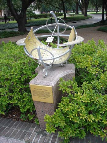
Return to your car and retrace your path back to the entrance of Herman park on Herman Loop Drive. Make the first right hand turn onto San Jacinto Street. Continue straight for 2.8 miles into downtown Houston. Turn Left at Lamar Street. Proceed 0.5 miles (7 blocks) to Bagby Street. Sam Houston Park is on the right. Park along the street. 3. Houston Armillary Sphere
This is a fine example of an armillary dial, 72-inches in diameter. The large vertical ring represents the meridian of Houston with time markings in hourly intervals. Representing the celestial equator, the outer band contains zodiac symbols. The attached plaque describes the working of the sundial and equation of time. From your car, turn left onto Dallas Street; proceed west 0.2 miles (4 blocks) and turn left onto Louisiana Street. Go 0.3 miles (5 blocks) and turn left on Capitol Street. Proceed 0.4 miles, and take Memorial Way on the right. Take the first left and merge onto I-45 South. Proceed 18.5 miles to exit 29, Clear Lake City Blvd. After exiting the expressway, turn left onto Clear Lake City Blvd and proceed 1.2 miles. After crossing Texas Highway 3, turn left into Crescent Landing Drive\Sylvan Rodriquez Park. Proceed to the end of the drive and park in the parking lot. Map 4A Map 4B Map 4C 4. Sylvan Rodriguez Park Astronomical Calendar
Leaving the park, turn right on Clear Lake City Blvd and then turn left in 0.2 miles going south on Texas Highway 3. Proceed 3.8 miles and turn left onto NASA Parkway. Go for 1.9 miles to Upper Bay Blvd. Turn right onto Upper Bay and continue straight to the end of the road. This is Nassau Park; the sundial is beside the picnic shelter. 5. Nassau Park Sundial
The Nassau Park sundial is a simple horizontal dial made of concrete and iron pipe. It is an excellent example that not all dials need exotic materials or an artistic flare. A simple dial can keep excellent time. Retrace Upper Bay Blvd back to NASA Parkway and turn right onto the highway. Proceed 1.1 miles and turn left on Space Center Blvd. Go 2.9 miles and turn right ont Bay Area Blvd. After 0.6 miles turn right onto University Drive at the entrance to the University of Houston Clear Lake campus. Park in the first parking lot. The building closest to Space Center Blvd is the Delta Building. The sundial is in front of the Delta Building. 6. Charles Pebworth Sundial.
Build in 1982 by Charles Pebworth to commemorate the space program, this sculpture also functions as two separate sundials. At the top is a equatorial dial. The vertical arc below functions as meridian dial at noon. Being a work of art, the dial hour marks are numberless. Unfortunately, the dial is located in dense shade. Exit the university campus and turn right onto Bay Area Blvd. Proceed 5.1 miles and turn right onto Choate Road. Then, after 0.5 miles, turn left onto Highway 146 North. Proceed 4.4 miles and take the exit onto Highway 225 West. Continue on for 3.8 miles and take exit for Battleground Road and turn right at the stop light. Continue straight on Battleground Road for 3.4 miles to San Jacinto State Historic Park. Enter the park on the left hand side of the road. The sundial is next to the concession stand. 7. San Jacinto Memorial The battle of San Jacinto was the final struggle in securing the independence of the Republic of Texas from Mexico. This 1200 acre historic site preserves the area where General Sam Houston lead Texas troops in a surprise attack against the forces of General Santa Anna on April 21, 1836. The obelisk contains a museum of the battle.
important area of the battlefield. Time on the dial is marked in 5 minute increments, Roman numerals mark the hours and the base has the Texas Seal and an eternal flame. This completes the basic Houston Sundial Tour. To return to the city, retrace your route on Battleground Road to highway 225. Turn west onto the highway and it crosses I-610, the loop expressway around Houston. If you have time or your travels take you to a specific area of the city, there are other interesting dials to see. Side Trips: A. Rainy Day Dials - The Museum of Fine Art Houston Starting from the first dial at Rice University, return to your car; make a left right onto Main St; and proceed 0.6 miles. Turn right onto Binz St and there is parking garage in the second block for a fee, or free parking across the street. The museum has a fee of $7.00 adult or $3.50 student and is open 10:00 am to 5:00 pm most days; closed Mondays and holidays.
1. Ivory Diptych Sundial by Paulus Reinmann, 1601 Located in room 217 on the second floor of the Audrey Jones Beck Building, this 16th century pocket dial measures 11.3 x 8.9 x 1.9 cm. It includes a compass for alignment, and both vertical and horizontal dials. The dial not only tells time, but also the date, by both the Julian and Gregorian calendars. A hole in the upper face allows the compass needle to be viewed even when closed. An altitude dial is on the back face of the dial. 2. Equinoctial Sundial by Nikolius Rugendas III, German 1665-1745
3. Hercules Upholding the Heavens by Paul Manship, 1918 Located in room 110 on the first floor of the Audrey Jones Beck Building, this wonderful 4 foot diameter armillary dial, marked in 15 minute increments, is titled "Hercules Upholding the Heavens." As described in the mythical story of the Labors of Hercules, this statue shows Hercules kneeling, with lion cape and club, holding the world (armillary dial) on his shoulders. The bronze statue is 10 feet tall. There are zodiac symbols on the outer band. B. Picture Perfect Dials
Helen's Garden park is a quiet, picturesque nook in the busy city. The flowers, fountains and peaceful setting encourages slow walks. Wedding parties often pause here for pictures that will last a lifetime. The 24 inch, bronze dial is another example of the equatorial construction. Time measured in hours, is shown in Roman numerals on the inner band. The outer band and base plate host zodiac symbols. Once in your car, turn right onto Main Street (FM-518) heading northeast for 1.1 miles. Angle to the left, on to FM-2094 (Marina Bay Drive) and proceed for another 3.4 miles. Turn left onto Clear Lake Road and as soon as you cross the inlet bridge (0.2 miles) turn left onto South Shore Drive. Sundial Park is in 0.5 miles (6 blocks). Parking is allowed on certain areas of the street. Please observe all parking regulations. 2. Sundial Park, Clear Lake Shores Sundial Park C. Day at the Beach When heading south on I-45 toward the Sylvan Rodriguez Park, instead of taking exit 29, continue south another 29.2 miles to the end of I-45. Continue straight on Broadway Avenue 2.7 miles to 23rd Street and turn left. Park in the Aston Villa parking lot. The dial is in the Harris Garden park at the corner of Broadway and 23rd; behind the gazebo Map C1 Map C2 Built in 1859, the Galveston Historical Foundation operates the Aston Villa, which is a fine example of Victorian architecture in Texas. Of course, being a barrier island, Galveston also offers all the fun and sun of the Texas Gulf Coast. 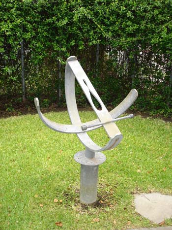 This
aluminum, equatorial dial has the shape of the equation of time cut into
a movable style. Month markings on the style allow accurate clock time to
be read on the dial face. The dial face is marked in 5 minute increments
in Arabic numerals. Both standard and daylight saving central time are shown.
The dial base hosts a compass rose. This
aluminum, equatorial dial has the shape of the equation of time cut into
a movable style. Month markings on the style allow accurate clock time to
be read on the dial face. The dial face is marked in 5 minute increments
in Arabic numerals. Both standard and daylight saving central time are shown.
The dial base hosts a compass rose.
D. Going West From the intersection of I-610 and I-10 proceed west on I-10 for 9 miles. Take the Eldridge Parkway exit and turn left under the I-10 bridge onto Eldridge Parkway. Take the first right after 0.5 miles onto Memorial Drive. The parking lot is 0.4 miles on the right. The sundial is on the top of the hill behind the picnic shelter. MAP D1
This is only example of an analemmatic sundial on the tour. By standing on the appropriate date in the center of the dial, you can become part of the time. The dates are marked on a granite slab in the center of the brick face. The hours are marked with Arabic numerals. |
 Beautiful
Rice University was founded in 1912 and today has over 5,000 students.
Based on a residential college system, the university's tree lined campus
and active student body can make for an interesting diversion. Enjoy a
concert or visit the art museum on campus.
Beautiful
Rice University was founded in 1912 and today has over 5,000 students.
Based on a residential college system, the university's tree lined campus
and active student body can make for an interesting diversion. Enjoy a
concert or visit the art museum on campus. 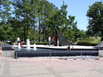 The
black granite, horizontal dial, erected in 1989, has time marked in 1
hr increments. The tetrahedral gnomon is capped with a ball containing
an orifice allowing light to pass through only on the solstice and equinox.
The dial face contains a silver analemma on the noon line to track the
date and adjust for the equation of time. A brown granite line running
due north of the gnomon marks solar noon. Small pyramids around the dial
mark the cardinal directions.
The
black granite, horizontal dial, erected in 1989, has time marked in 1
hr increments. The tetrahedral gnomon is capped with a ball containing
an orifice allowing light to pass through only on the solstice and equinox.
The dial face contains a silver analemma on the noon line to track the
date and adjust for the equation of time. A brown granite line running
due north of the gnomon marks solar noon. Small pyramids around the dial
mark the cardinal directions. 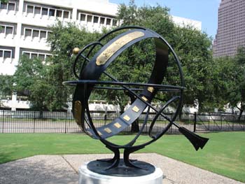 The
Sam Houston Park is part of the Houston Heritage Society and contains
historic buildings from various periods of Houston's history. The society
also maintains a museum just south of the park to preserve the rich historic
lore of this growing western town. The Houston Armillary Sphere is in
the northeast corner of the park.
The
Sam Houston Park is part of the Houston Heritage Society and contains
historic buildings from various periods of Houston's history. The society
also maintains a museum just south of the park to preserve the rich historic
lore of this growing western town. The Houston Armillary Sphere is in
the northeast corner of the park.  The
Sylvan Rodriguez Park is a family park built on an astronomical theme.
Filled with ballfields, playgrounds, ponds, and walking paths, the highest
rise contains an astronomical calendar.
The
Sylvan Rodriguez Park is a family park built on an astronomical theme.
Filled with ballfields, playgrounds, ponds, and walking paths, the highest
rise contains an astronomical calendar. 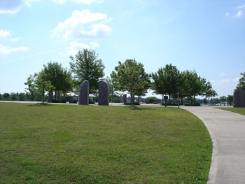 While
technically not a sundial, this solar observatory marks the summer and
winter solstices as the sun rises and sets through a pair of split monolithic
stones forming a gateway. The brick and limestone plaza also has indications
of cardinal directions on the outer ring and 13 trees to mark the 13 lunar
cycles in a year. The inner court contains a copy of the Chartres Labyrinth.
Designed and built by Dixie Friend Gay in 2001, this is a restful place
to observe the movements of the sun throughout the year.
While
technically not a sundial, this solar observatory marks the summer and
winter solstices as the sun rises and sets through a pair of split monolithic
stones forming a gateway. The brick and limestone plaza also has indications
of cardinal directions on the outer ring and 13 trees to mark the 13 lunar
cycles in a year. The inner court contains a copy of the Chartres Labyrinth.
Designed and built by Dixie Friend Gay in 2001, this is a restful place
to observe the movements of the sun throughout the year. 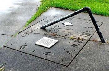 In
driving along NASA Parkway, you pass the NASA Johnson Space Center on
the left. This is the headquarters for manned space flight in the United
States. It is well worth a visit. The Nassau Park is a favorite for bird
watchers as Clear Lake provides a excellent marsh habitat.
In
driving along NASA Parkway, you pass the NASA Johnson Space Center on
the left. This is the headquarters for manned space flight in the United
States. It is well worth a visit. The Nassau Park is a favorite for bird
watchers as Clear Lake provides a excellent marsh habitat. 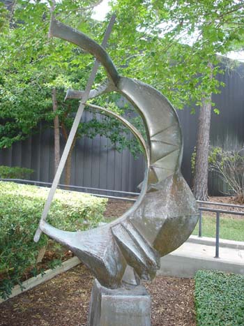 University
Nestled on a 524 acre nature preserve, the University of Houston Clear
Lake is an excellent place to get closer to wild Texas. Please be careful
of alligators, coyotes, and other wildlife.
University
Nestled on a 524 acre nature preserve, the University of Houston Clear
Lake is an excellent place to get closer to wild Texas. Please be careful
of alligators, coyotes, and other wildlife. 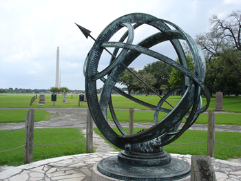 This
is a bronze Equatorial - Armillary sphere sundial with a 12 foot diameter.
The dial was dedicated in 1939 by the San Jacinto Chapter of the Daughters
of the Republic of Texas to commemorate those that fell in the final battle
for independence. The dial base lists those fallen. The inscription states
"The hours, days, and years of unfolding time shall never dim the spirit
of liberty kindled on this field of battle" Each path radiating from the
dial directs the visitor to an
This
is a bronze Equatorial - Armillary sphere sundial with a 12 foot diameter.
The dial was dedicated in 1939 by the San Jacinto Chapter of the Daughters
of the Republic of Texas to commemorate those that fell in the final battle
for independence. The dial base lists those fallen. The inscription states
"The hours, days, and years of unfolding time shall never dim the spirit
of liberty kindled on this field of battle" Each path radiating from the
dial directs the visitor to an 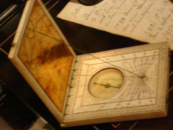 The MFAH is a world class museum with works spanning the centuries. It
will be easy to get lost among the art on your way to the sundiasl. All
dials are located in the Audrey Jones Beck building.
The MFAH is a world class museum with works spanning the centuries. It
will be easy to get lost among the art on your way to the sundiasl. All
dials are located in the Audrey Jones Beck building. 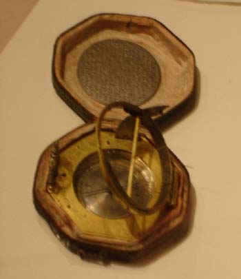 Also
located in room 217 is pocket equinoctial dial measuring 5.8 x 5.5 x 1.5
cm. Made in the 17th century, this dial includes both a compass and a
miniature plumb bob for leveling the dial. The leather case includes a
list of major cities in Europe and the Holy Lands.
Also
located in room 217 is pocket equinoctial dial measuring 5.8 x 5.5 x 1.5
cm. Made in the 17th century, this dial includes both a compass and a
miniature plumb bob for leveling the dial. The leather case includes a
list of major cities in Europe and the Holy Lands. 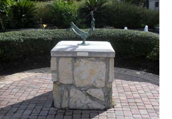 When
heading south on I-45 toward the Sylvan Rodriguez Park, instead of taking
exit 29, continue south another 5.4 miles to exit 23, FM-518. Turn left,
going under the expressway bridge, and continue straight on FM-518 (Main
Street) for 1.7 miles; then turn left on Kansas Avenue. The park is immediately
on the right. Park in the parking lot or street. The dial is in the center
of this small park.
When
heading south on I-45 toward the Sylvan Rodriguez Park, instead of taking
exit 29, continue south another 5.4 miles to exit 23, FM-518. Turn left,
going under the expressway bridge, and continue straight on FM-518 (Main
Street) for 1.7 miles; then turn left on Kansas Avenue. The park is immediately
on the right. Park in the parking lot or street. The dial is in the center
of this small park. 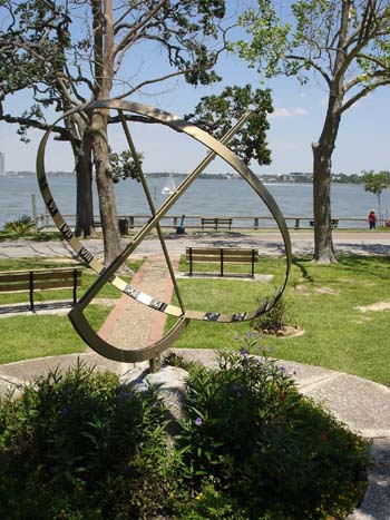 The sundial is the centerpiece of this miniature park. Located on the
shore of Clear Lake, the neighbors gather here on mild summer evenings
to watch the sunset across the lake. The 6 foot equatorial dial's style
is light and airy. Constructed of painted iron, the dial is marked in
one hour increments with roman numerals.
The sundial is the centerpiece of this miniature park. Located on the
shore of Clear Lake, the neighbors gather here on mild summer evenings
to watch the sunset across the lake. The 6 foot equatorial dial's style
is light and airy. Constructed of painted iron, the dial is marked in
one hour increments with roman numerals. 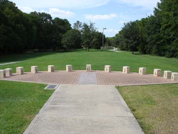 Terry
Hersey Park runs the length of scenic Buffalo Bayou with over 10 miles
of hike and bike trails. A great place to exercise in the open air; or
if you prefer indoor activities, go west on I-10 for another 9.7 miles
to Katy Mills Shopping Center for a day of shopping and dining.
Terry
Hersey Park runs the length of scenic Buffalo Bayou with over 10 miles
of hike and bike trails. A great place to exercise in the open air; or
if you prefer indoor activities, go west on I-10 for another 9.7 miles
to Katy Mills Shopping Center for a day of shopping and dining.